
Durango Bill's
Grand Canyon 3-D Tour
Unkar Creek to Hance Rapid to Cottonwood Creek
Grand Canyon Miles 72 to 80
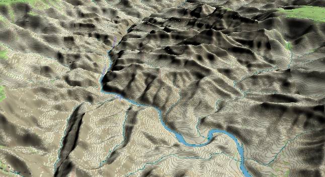
The foreground in
this view to the west illustrates how Unkar Creek’s debris fan
deflects the Colorado River. Unkar Creek originates off the
North Rim (right) and drains the easily eroded Dox Formation.
The large amount of debris that it deposits pushes the river
to the left out of its normal course.
In relatively recent times, some of these debris flows have created small dams at Unkar Delta. The river would then back up and deposit a lot river gravel upstream from these dams before it could cut back down to its original level. Remnants of these old river gravel deposits are still visible along both sides of the river for half a dozen miles back upstream.
A few miles further downstream the up-to-the-west tilt of the Grand Canyon Supergroup brings the much harder Shinumo Quartzite above ground level to form a cliff just before the river turns westward.
The small segment of the South Rim visible in the upper left corner is Shoshone Point (a few miles east of Grand Canyon Village), while Wotans Throne, Cape Royal, and a small section of the Walhalla Plateau (North Rim) can be seen in the upper right corner.
The river gradient continues steeper in the western Dox area than it was east of the Butte Fault. Then, the steepest river gradient in the entire Grand Canyon is encountered in the area around Hance Rapid after the sharp bend in the river toward the west-northwest.
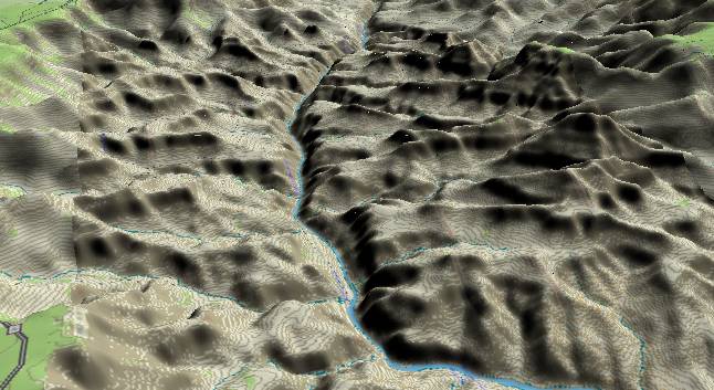
View to the
west-northwest. In the foreground the Colorado River turns
a corner and plunges down Hance Rapid with the average
river gradient in this section (about 18 ft/mi) the
steepest in the Grand Canyon. The steep gradient is a
result of three different factors. First, the debris fan
from Red Canyon (enters from left edge) would normally
create a rapid. Next, this area is on the west (downhill)
side of the axis of the Kaibab Plateau. Finally, the river
is crossing from the hard Shinumo Quartzite to the more
easily eroded underlying Hakatai Shale.
As part of the Grand Canyon Supergroup, the Hakatai Shale also tilts upward to the west and forms a small upward tilting slope in the right side of the canyon just below Hance Rapid. Then at the river's leftmost position in the picture, the Bass Limestone and Vishnu Schist are encountered and the river enters Upper Granite Gorge.
River mile 80 is reached where the river turns slightly further to the right before disappearing from view. Cottonwood Creek enters from the left just after this bend to the right.
Return to river miles 64 to 72
Continue to river miles 80 to 88
Return to the Index Page for the Grand Canyon Tour
Web page generated via Sea Monkey's Composer HTML editor
within a Linux Cinnamon Mint 18 operating system.
(Goodbye Microsoft)