
Durango Bill's
Grand Canyon 3-D Tour
Temple Butte to Tanner Creek/Rapid to Unkar Creek
Grand Canyon Miles 64 to 72
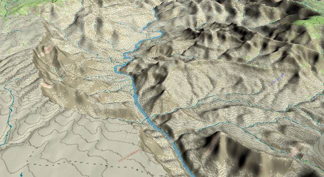
View to the
southwest with Temple Butte in the right foreground and
Palisades Creek (First creek on the left side, but partly
obscured) in the left foreground. A portion of the South
Rim can be seen in the upper left corner. Also, a small
portion of the Walhalla Plateau (North Rim) can be seen in the
upper right corner.
This section of the Grand Canyon opens up with few cliffs near the river. For the next 10 miles the open areas bordering the river consist of the 3,000-foot thick Dox Formation. Layers in the Dox are mostly poorly cemented siltstones and sandstones deposited in a near sea level environment about 1,100 million years ago. Unlike most of the rest of the Grand Canyon, the Dox erodes easily and has few cliffs. The Butte Fault has two major branches that cross the river in this section. One branch crosses from right (just in back of Temple Butte) to left (up Palisades Creek). A second branch crosses the river at Tanner Rapid (Just out of sight near the center of the picture) and continues to the left up Tanner Canyon.
This section of the Grand Canyon opens up with few cliffs near the river. For the next 10 miles the open areas bordering the river consist of the 3,000-foot thick Dox Formation. Layers in the Dox are mostly poorly cemented siltstones and sandstones deposited in a near sea level environment about 1,100 million years ago. Unlike most of the rest of the Grand Canyon, the Dox erodes easily and has few cliffs. The Butte Fault has two major branches that cross the river in this section. One branch crosses from right (just in back of Temple Butte) to left (up Palisades Creek). A second branch crosses the river at Tanner Rapid (Just out of sight near the center of the picture) and continues to the left up Tanner Canyon.
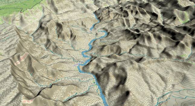
View to the
southwest with Lava Butte to the right of the river just above
the lower edge. Tanner Creek originates near the South Rim on
the left side of the picture, and generates Tanner Rapid where
it joins the Colorado (after the river completes its first
turn to the right). Somewhat further in the distance, Unkar
Creek joins the river and forces the river to bend to the left
- briefly out of sight. In the far distance the Shinumo
Quartzite (the next layer down in the Grand Canyon Supergroup)
forms a cliff just before the river turns to the right out of
view.
A major branch of the Butte Fault crosses the river at Tanner Rapid. If you are rafting the river, you can see a block of strata that has been faulted downward in Precambrian time just to the west of the fault. More recently, movement on this fault has reversed to lift the area west of the fault (but not as much). It is interesting to note that river gradient from here westward increases implying that the fault (or doming along the entire East Kaibab) is still active.
While the Dox Formation and other layers of the Grand Canyon Supergroup are best exposed in this area, the more familiar Paleozoic layers can still be recognized in higher layers. For example the Tapeats Sandstone forms a protective cap for the ridge in the lower right quadrant. Just above this unnamed ridge, the sheer Redwall Limestone cliff can be seen on Apollo Temple.
Return to river miles 56 to 64
Continue to river miles 72 to 80
Return to the Index Page for the Grand Canyon Tour
Web page generated via Sea Monkey's Composer HTML editor
within a Linux Cinnamon Mint 18 operating system.
(Goodbye Microsoft)