
Durango Bill's
Grand Canyon 3-D Tour
Kwagunt Creek to Little Colorado River to Temple Butte
Grand Canyon Miles 56 to 64
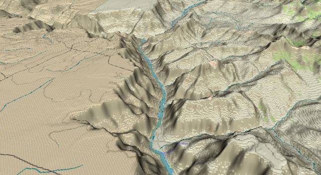
View to the south
with Kwagunt Creek entering from the lower right and the
Little Colorado River in the distance on the left. Chuar Butte
is immediately to the right of the junction of the Little
Colorado and Colorado Rivers. The Butte Fault can be traced
upward from the lower right corner to just west (right) of
Chuar Butte.
The steep cliffs near the river are formed by a combination of the Redwall and Muav Limestones while the slope right next to the river is the Bright Angel Shale. Meanwhile the Kaibab Limestone still forms a flattish surface left (east) of the river. The area to the west (right) of the Butte Fault exposes the upper, easily eroded layers of the Grand Canyon Supergroup.
The Grand Canyon Supergroup was deposited during the period between 1,200 million and 800 million years ago. A billion years ago, the current Grand Canyon area was near the southern (relative to today's orientation) edge of the large super-continent "Rodinia". The Grand Canyon Supergroup is one of the few remaining samples of sediment deposits from this era. At that time, present-day Australia was attached to western North America and was just to the west of the Grand Canyon area.
About 700 to 800 million years ago, Rodinia broke apart into pieces with North America becoming an isolated island (Similar to today's Australia). Then about 300 million years ago the continents joined together again to form another super-continent called Pangea. 200 million years ago Pangea broke up with North America drifting westward 1 to 2 inches a year. The gap is now filled by the Atlantic Ocean.
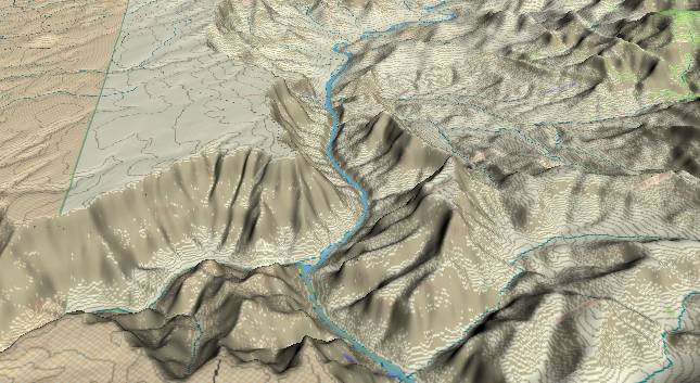
View to the
south-southwest with the Little Colorado River in the
Lower left corner. Chuar Butte is just to the right of the
junction of the Little Colorado and Colorado Rivers with
Temple Butte just above it. The East Fork of Carbon Creek
(small streamlet to the right of Temple Butte) marks the
Butte Fault with the fault continuing across the river
into Tanner Creek. (More info on this section of the Butte
Fault on the next page in the sequence.) The Tapeats
Sandstone, the lowest layer in the Paleozoic rock layers,
forms the small cliff next to the river in the center of
the picture.
The near continuous 3,000-foot high cliff just left of the center of the picture is named “Palisades of the Desert”. If you visit the South Rim of the Grand Canyon, the Palisades of the Desert can be seen from several of the overlooks on the eastern portion of the South Rim Highway.
The upstream path of the Little Colorado River (not visible in the picture) before it joins the main Colorado River is of some interest. The Colorado River gradually turns toward the southwest without paying any attention to the fact that it is turning into the rising strata of the Kaibab Plateau. This implies it established its course before the most recent 1,400 foot uplift of the plateau. The Little Colorado River turns north for 15 miles on the east side of the Kaibab Plateau before it finally turns west to join the Colorado. This implies it “was aware” of the Kaibab, and was trying to avoid the rising strata. There is a suggestion here that the Little Colorado didn’t have enough water to reach the Colorado until a couple of million years after the main Colorado pioneered the route. A possible sequence of events might be:
1) 5.4 million years ago, the Colorado River established its current route.
2) 5.4 to 3 million years ago, the Kaibab Plateau started its most recent uplift.
3) 3 million years ago (and maybe less), the climate became wet enough for the Little Colorado River to reach the main river, and only then did it establish its route.
Return to river miles 48 to 56
Continue to river miles 64 to 72
Return to the Index Page for the Grand Canyon Tour
Web page generated via Sea Monkey's Composer HTML editor
within a Linux Cinnamon Mint 18 operating system.
(Goodbye Microsoft)