
Durango Bill's
Grand Canyon 3-D Tour
Saddle Canyon to Kwagunt Creek
Grand Canyon Miles 48 to 56
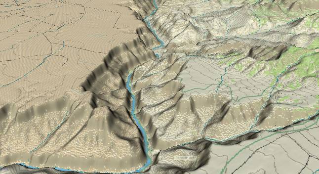
View to the
south-southeast with Saddle Canyon in the lower right corner.
Further downstream Little Nankoweap and Nankoweap Creeks enter
from the right. Nankoweap Creek produces a large delta
(outwash fan) as its drainage taps the easily eroded upper
layers of the Grand Canyon Supergroup.
The topography of the Grand Canyon begins to change from about Saddle Canyon downstream. The rim on the east (left) side is still the flattish Kaibab Limestone of the Marble Platform, but to the west (right), first the encroachment of the Kaibab Plateau produces an upslope, and then everything changes dramatically (see below).
The topography of the Grand Canyon begins to change from about Saddle Canyon downstream. The rim on the east (left) side is still the flattish Kaibab Limestone of the Marble Platform, but to the west (right), first the encroachment of the Kaibab Plateau produces an upslope, and then everything changes dramatically (see below).
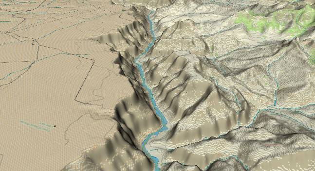
View to the
south-southeast with Nankoweap Canyon and its outwash fan in
the foreground. In the middle distance Kwagunt Creek enters
from the right to produce another outwash fan. The Canyon of
the Little Colorado River can be seen left of center at the
top edge. To the right of the Colorado River a small remnant
of the flattish Marble Platform remains on top of Nankoweap
Mesa. Then everything becomes chaotic west (right) of the
Butte Fault.
The Butte Fault (East Kaibab Monocline) enters from the lower right edge and then curves upward toward the top of the picture. Initial movement along this fault some 800 million years ago dropped the strata to the right (west) some 3,000 to 4,000 feet lower than layers to the east. When the Grand Canyon Supergroup was faulted downward, it was protected from further surface erosion. Subsequently, the same Paleozoic layers that form the Marble Canyon section of the Grand Canyon covered the Supergroup layers.
In the last 70 million years movement along the fault has been in the opposite direction and the area to the west of the fault has been uplifted (probably 3 separate uplifts) to form the Kaibab Plateau. (These uplifts include doming over a wider area than just the fault zone.) When the Colorado River established its current route some 5.4 million years ago, areas closest to the river were subject to the greatest erosion, and the Paleozoic layers were eroded away. Once these upper layers were gone, erosion could rapidly erode the softer Grand Canyon Supergroup. Thus topography to the right of the fault zone has been eroded down lower than the few high mesas (e.g. Nankoweap) that are found right next to the river. The rapid erosion (includes debris flows) of the soft Supergroup layers feeds the outwash fans (deltas) of Nankoweap and Kwagunt Creeks.
Return to river miles 40 to 48
Continue to river miles 56 to 64
Return to the Index Page for the Grand Canyon Tour
Web page generated via Sea Monkey's Composer HTML editor
within a Linux Cinnamon Mint 18 operating system.
(Goodbye Microsoft)