
Durango Bill's
Grand Canyon 3-D Tour
Badger Creek to Rider Canyon
Grand Canyon Miles 8 to 16
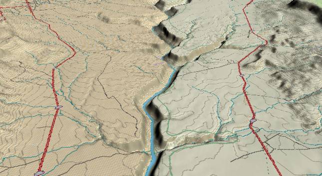
View to the
southwest with Badger Creek in the right foreground, Soap
Creek to the right (west) of the river in the middle distance,
and Rider Canyon to the west of the river near the top edge.
Jackass Creek is on the left side of the river in the
foreground. Sections of US highway 89A are receding toward the
left and right edges.
The contour lines (50-foot intervals) show that the flattish Kaibab Limestone actually dips downward toward the foreground. If you are rafting the Colorado River, there is an illusion that you are rapidly plunging downward through multiple strata layers. Actually the river only drops 5 to 8 feet per river mile in this section, while the strata slope steadily upward to the south.
The cliff portion of the canyon comprises the Kaibab, Toroweap, and Coconino Formations which typically erode into cliffs. A little above the center of the picture, especially where Soap Creek enters from the right, the more easily eroded Hermit Shale forms a slope. The total canyon depth at Soap Creek Canyon is 1,000 feet, and steadily deepens as you travel downstream.
According to legend, Badger and Soap Creeks got their names when an early explorer shot a Badger near here. Then, he tried boiling it in water which unfortunately was somewhat alkaline, and ended up with soap.
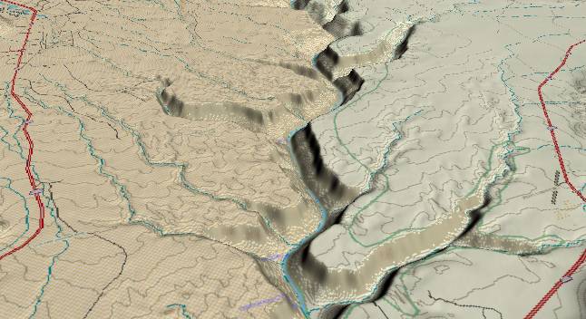
View toward the
south-southwest. Soap Creek Canyon is visible at the lower
right. Tanner Wash enters from the left while Rider Canyon
enters from the right just above the center of the picture.
By the time you get to Rider Canyon you have descended into the 5th strata layer as measured from the rim. The Kaibab, Toroweap, and Coconino Formations form the upper cliff. Then the Hermit Shale forms a slope. Finally, the Supai Group starts forming another cliff next to the river. The Supai has multiple layers of siltstone, sandstone, and limestone and is recognizable as a series of small cliffs and slopes. The net result is a "stair step" appearance that is steeper than the Hermit Shale, but not as steep as the Kaibab/Toroweap/Coconino cliff. The uppermost layer in the Supai Group is the Esplanade Sandstone, which becomes far more significant in the western portions of the Grand Canyon.
The rapid where debris from Rider Canyon enters the Colorado is named House Rock Rapid. Our "famous" early explorer camped here under a rock "as large as a house" in Rider Canyon, and the river rapid preserves the name.
Return to river miles 0 to 8
Continue to river miles 16 to 24
Return to the Index Page for the Grand Canyon Tour
Web page generated via Sea Monkey's Composer HTML editor
within a Linux Cinnamon Mint 18 operating system.
(Goodbye Microsoft)