
Durango Bill's
Grand Canyon 3-D Tour
Lees Ferry to Badger Creek
Grand Canyon Miles 0 to 8
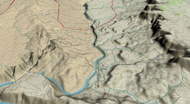
View to the
southwest with Lees Ferry in the foreground and US highway 89A
in the background. The Paria River enters from the lower edge
to the right of the center. All Grand Canyon raft trips start
at Lees Ferry. About one third of the way from Lees Ferry to
the highway bridge the river starts cutting down through the
Kaibab Limestone. This is the start of the Marble Canyon
section of the Grand Canyon.
At Lees Ferry, the easily eroded Triassic Age Chinle and Moenkopi Formations intercept the Colorado River. Where these layers erode down to the highly resistant, flattish Kaibab Limestone they allow the only highway access to the Colorado River for about 200 miles upstream and 300 miles downstream.
The more resistant Shinarump Conglomerate is found between the Chinle and Moenkopi, and serves as a protective surface for the 400-foot high mesas seen a short distance to the right (west) of the river. The high Vermillion Cliffs topped by the Navajo Sandstone can be seen in the upper right quadrant, and soar more than 3,000 feet above the river. As the weak Chinle Formation underlying these cliffs erodes, support for the cliffs is gradually removed until slabs break off and slowly slide downward. These broken slabs slowly erode exposing addition sections of the cliffs to erosion. Thus, the cliffs gradually erode back from the river.
The highway crosses the river some four miles below Lees Ferry. The original one-lane bridge was built in 1929, but a wider bridge has been built in recent years. The original bridge is still used by pedestrians to view the upper end of the canyon. The bridge itself is over 400 feet above the river.
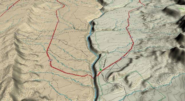
The first major
rapid that rafters encounter occurs where Jackass (left)
and Badger (right) Creeks join the river (slightly above
the center of the picture). All the significant rapids
within the canyon are found where side canyons join the
main canyon. When a flash flood occurs in these side
canyons, the steep gradient provides enough energy to the
down rushing water to enable it to carry large rocks and
other debris down to the Colorado River. This debris forms
a small dam in the main river, and a river rapid is formed
where the Colorado pours over the lower portion of the
outwash fan.
The twin canyons (Jackson and Badger) are a result of a small fault that crosses the river at this location. In contrast to most faults that are caused by tectonic action, this fault is a result of isostatic rebound of the downstream surface after erosion has removed 3,000 feet of rock that at one time was part of the Vermillion Cliffs. The downstream (far) side of these canyons has shifted upward by some 10 to 20 feet, but this minor faulting has shattered the underlying rock in the fault zone. The shattered rock was easily removed by surface erosion which in turn led to the development of the canyons.
Before the Glen Canyon Dam was built, large volumes of water would come down the Colorado when the snow pack in the high Rockies melted each spring. This high volume runoff would periodically wash away some of the debris fans - thus keeping the size of the rapids in check. Now that Glen Canyon Dam holds back the spring floods, there is nothing to diminish the size of the side canyon debris fans. Thus the rapids in the canyon will become bigger each time a flash flood washes down more rocks.
Return to the Glen Canyon Page
Continue to River Miles 8 to 16 - Badger Creek to Rider Canyon
Return to the Index Page for the Grand Canyon Tour
Web page generated via Sea Monkey's Composer HTML editor
within a Linux Cinnamon Mint 18 operating system.
(Goodbye Microsoft)