
Durango Bill's
Grand Canyon 3-D Tour
Glen Canyon from Page, AZ to Lees Ferry, AZ (15.5 river miles)
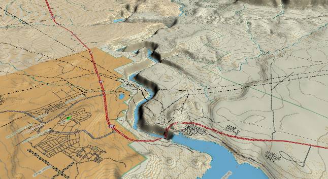
This first picture
is a view looking southwest from Lake Powell (lower edge),
which is the upstream reservoir above Glen Canyon Dam. The
major highway is US 89 with the town of Page, AZ occupying the
lower left quadrant of the picture.
The early Jurassic Navajo Sandstone dominates surface rock in this area. 200 million years ago, climate conditions here were similar to modern-day Egypt. River systems flowing north from southern Arizona and westward from Texas carried silt and sand into much of northern Arizona and southern Utah just as the modern Nile River carries silt and sand northward from central Africa to Egypt. (Latest evidence as of September 2003 indicates a large portion of this sand originated in the present Appalachian Mountains.) During dry periods, the rivers would shrink, and as the latest silt layer dried, winds would blow the sand into dunes - just like the modern Sahara Desert.
The annual process was repeated for millions of years with the dunes accumulating to over 1,000 feet in thickness. They were converted into sandstone rock when they were subsequently buried by thousands of feet of other sediments. However, if you have a chance to examine the Navajo Sandstone, traces of these ancient sand dunes can be readily seen.
In the last 5 million years erosion by the Colorado River has uncovered the Navajo. The daily heating and cooling from the sun (expansion followed by contraction) weakens whatever surface layer is exposed. Then, when the legendary thunderstorms and flash floods finally arrive, they wash another thin layer down to the Colorado River, which in turn transports the sand and silt to its delta in the Gulf of California.
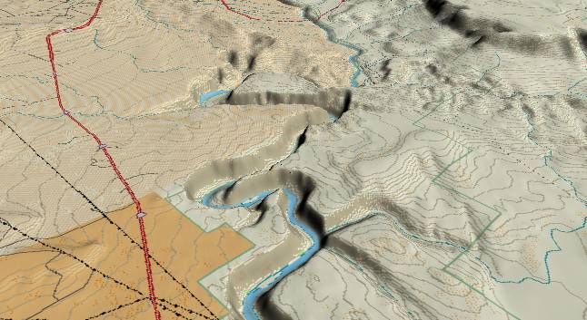
The second picture
(centered a few miles southwest of picture 1 and still looking
southwest) illustrates entrenched meanders in the Colorado
River. These meanders developed shortly after the Colorado
River found its new route across the Kaibab Plateau about 5.4
million years ago. This area was part of the flat silt plain
that had backed up behind the Colorado's old course across the
rising Wasatch Ranges. When the Colorado switched to its
current path, it was still crossing the flat silt plain. The
river developed meanders similar to meanders seen in the
current Mississippi River. Then, as the Colorado River cut
down through the Kaibab Plateau, canyon cutting worked its way
back upstream. In classical fashion, the river cut downward
into the old sandstone layers and became trapped in its former
meandering course.
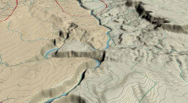
The third
picture shows the extreme southwest end of Glen Canyon.
Lees Ferry (the put-in location for Grand Canyon raft
trips) is located where the river becomes completely
visible again. In the distance highway US 89A crosses the
river over Navajo Bridge. To the right the Paria River
enters from the right edge. The Paria Plateau is just
above it.
Surface rock in the foreground is still the Navajo Sandstone. The red/orange/reddish-brown Triassic Age Moenave Formation is found in the lower parts of the canyon and forms the brilliant cliffs just to the northeast of Lees Ferry.
Continue to Grand Canyon - River Miles 0 to 8
Return to the Index Page for the Grand Canyon Tour
Web page generated via Sea Monkey's Composer HTML editor
within a Linux Cinnamon Mint 18 operating system.
(Goodbye Microsoft)