
Durango Bill’s
Ancestral Rivers of the World
Ancestral Rivers
in Europe
by
Bill Butler
by
Bill Butler
Antecedence and superimposition are geologic processes that explain how and why rivers can cut through mountain systems instead of going around them. The examples here (including pictures) are from Europe, but other examples can be found throughout the world.
Featured Areas
Danube River, Serbia /
Romania
Fier River, France
Labe River (Elbe River), Czech Republic
Olt River, Romania
Rhine River, Germany
Salzach River (Salzburg River), Austria
Unknown tributary to the Pechora River, Ural Mountains, Russia
Fier River, France
Labe River (Elbe River), Czech Republic
Olt River, Romania
Rhine River, Germany
Salzach River (Salzburg River), Austria
Unknown tributary to the Pechora River, Ural Mountains, Russia
Danube River,
Serbia / Romania
In Johann Strauss’ famous waltz, The Blue Danube, the river is blue as outlined in the picture below. In reality, the river is usually muddy as its geologic job is to transport sediment from its headwaters to its delta.
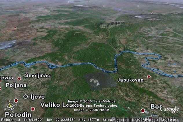
In the view above the Danube River is flowing from west to east (left to right) through the southwest end of the Transylvanian Alps. (The Transylvanian Alps are further subdivided into local mountain ranges.) The river also forms the border between Serbia on the near side of the river with Romania on the far side.
River elevations on the upstream (left) side of the mountains are about 200 feet above sea level and about 100 feet above sea level on the downstream (right side). The Transylvanian Alps adjacent to the river are a little over 2,000 feet above sea level, and thus the river gorge is about 2,000 feet deep.
The age of the Transylvanian Alps is not known, but an eyeball estimate would put their entire uplift history in the last 30 million years. Google Earth shows several recent earthquakes (not displayed in this more distant view) including a 1991 quake with a magnitude of 5.7 just above and to the right of center. Thus the range is continuing to undergoing a slow uplift at the present time.
As with most examples of rivers taking an “illogical” path through a mountain range, the Danube is another example of “antecedence”. When the Danube originally established its course, the Transylvanian Alps did not exist. If you could look at the area before the Transylvanian Alps were uplifted, you would see a flat plain with the Danube flowing in its present course across the lowlands.
The river’s elevation closely approximates what it was 30 million years ago. Thus, it is not the river that has cut down into the mountains. As the mountains rose the Danube played the part of a stationary band and abraded a slice of rising material that kept “getting in the way”. This is how the river has been able to maintain its original course.
Fier River,
France
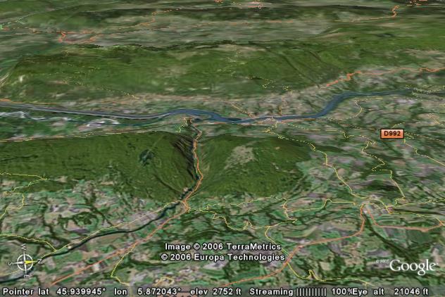
The picture above looks west across the Rhone Valley, France, some 25 miles southwest of Geneva, Switzerland. The Rhone River itself enters from the right edge and flows south-southwestward off the left edge. Of interest is the long, uplifted ridge that begins just below the center of the picture and continues off the left edge. The Fier River has “illogically” split this ridge instead of taking a nice easy route around the right end. The split portions are the Montagne des Princes to the right of the Fier’s gorge and Le Gros Foug on the left. In between, the Fier has cut a 2,000-foot deep canyon.
The long ridge that has been cut by the Fier is at the southern end of the Jura Mountains. The Jura Mountains in turn are the place name for the Jurassic geologic time period as their core rock layers date to ~144 to ~208 million years ago. Most readers will associate the name “Jurassic” with the Jurassic Park movie and immediately think of Tyrannosaurus Rex dinosaurs. There were a lot of dinosaurs during the Jurassic, but T. Rex didn’t show up for the party until nearly 100 million years later, and then he only existed in western North America which is a long way from the Jura Mountains.
Earthquake icons in Google Earth indicate mountain building in this area is still in progress. There were two magnitude 4-5 earthquakes less than ten miles to the northeast of the gorge in 1996, and several dozen others (mostly smaller) within a 20 mile range. The uplift history of the Montagne des Princes / Le Bros Foug ridge is not known, but it looks very recent. The Fier River Gorge has very steep sides indicating it is less than 5 million years old.
It seems probable that the gorge is another example of antecedence. The Fier River was in place first. As the ridge rose, the river played the part of a stationary band saw and eroded away the rising mountain that kept trying to “get in the way”.
The Fier River is not the only river that has cut a gorge through some of the ridges in the Jura Mountains. If you have Google Earth, you will find other gaps in the mountain ridges - especially in the area some 15 to 30 miles west-southwest of Geneva. Happy exploring.
Labe River (Elbe
River), Czech Republic
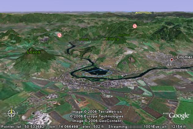
In the view above the Labe River flows north-northwestward into two branches of the Ore Mountains. At Praha (Prague - capital of the Czech Republic) which is some 35 miles to the south-southeast (upstream and off the lower right edge of the picture) the river elevation is about 600 feet above sea level. Where the Labe River enters the mountains in the picture, it is about 480 feet above sea level. The mountains typically rise to 1,500 to 2,000 feet above sea level.
The uplift history of the Ore Mountains is not known. “Eyeball” examination and the recent moderate earthquake activity suggest a maximum age of about 10-15 million years. It is assumed that the Labe River Gorge is another example of antecedence.
The yellow line in the distance marks part of the border between the Czech Republic and Germany. Once inside Germany the river’s name changes to the more familiar Elbe, and from there it continues to the North Sea.
Olt River,
Romainia
The view above looks toward the south where the Olt River cuts through the Transylvanian Alps. The Olt enters from the lower left edge, cuts through the mountains, and eventually joins the Danube River. (Flows from right to left in the distance.)
The river is about 1,200 feet above sea level just before it cuts through the mountains and about 600 feet above sea level on the far side. The Transylvanian Alps rise to 6,500 to 7,500 feet within a 10-mile range of both sides of the river. Thus the canyon is about a mile deep, which is roughly comparable in depth to Arizona’s Grand Canyon.
The geologic history of the Olt River is somewhat similar to the Danube in that it cuts through the Transylvanian Alps. However, the Olt cuts through some 120 miles east-northeast of the Danube, and as seen, the mountains are much higher.
Rhine River,
Germany
If you have ever traveled on a Rhine River cruise, you probably went through the gorge where the Rhine River has cut through the Hunsruck Taunus Mountains.
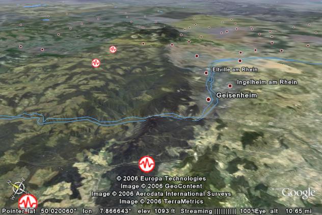
The view above looks east- northeast along an active fault zone in western Germany. The fault itself runs from the bottom edge (right of center) up to the top of the picture. The area to the right of the fault is extensively farmed lowlands, and elevations near the river are less than 300 feet above sea level.
To the left of the fault, the land has been uplifted to form a plateau which varies from 1,000 to 2,000 feet above sea level. We ask: Which direction does the river flow? By now, you should “smell a rat”.
The Rhine River flows from right to left, from the lowlands into the highlands where it cuts a gorge some 1,500 feet deep.
The Hunsruck Taunus Mountains are very young. The steep sides of the gorge and relatively minor erosional pattern on top of the plateau suggest a maximum age of about 10 million years.
If we turned the clock back 10 million years, the Rhine River probably closely approximated its present path. The mountains hadn’t been uplifted yet. Thus the Rhine followed the lowest route across a relatively featureless plain.
The Hunsruck Taunus Mountains have been uplifted over the last 10 million years. As the mountains rose, the Rhine had enough erosion power to maintain its original elevation. The river itself is about the same elevation above sea level that it was 10 million years ago. As the mountains rose, the river simply abraded away material that kept trying to get in the way.
Salzach River
(Salzburg River), Austria
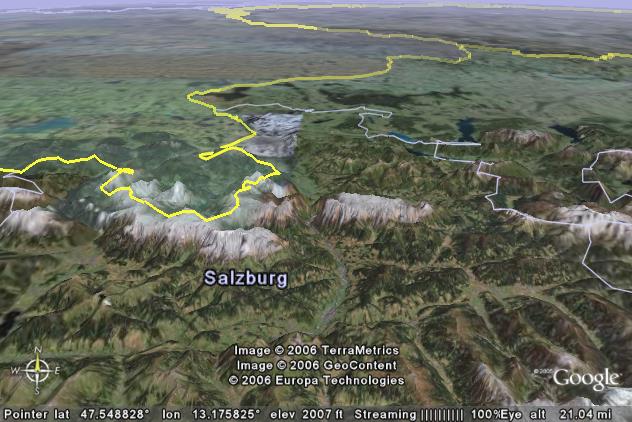
The view above looks northward across northwestern Austria. (Germany is to the left of the yellow line marking the border.) The city of Salzburg is in the white area in the distance. (Astronaut / satellite photographs are taken at different times of the year which produces different colors.) Salzburg is famous as the birthplace of Wolfgang Amadeus Mozart, and the city has been recounting the story ever since.
The Salzach River also has a story to tell but this one covers 30 million years of geologic history. The Alps are a young mountain range and have been essentially uplifted from scratch over the last 30 million years. There were ancestral rivers here before then, included the portion of the Salzach River that splits the high mountains in the center of the picture. The two mountains are over 7,000 feet high while the river elevation between them is about 1,600 to 1,700 feet above sea level. Thus the gorge is over one mile deep.
The story here is similar to that of the other ancestral rivers, and is another example of antecedence. The river was in place first, and as the mountain range rose, the Salzach had enough erosion power to cut down as fast as the mountains rose. Thus it was able to maintain its original course.
Unknown tributary
to the Pechora River, Ural Mountains, Russia
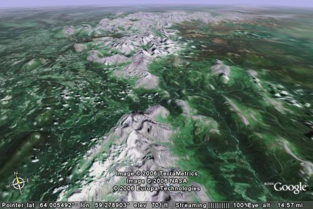
The picture above looks northward over the northern Ural Mountains in Russia. An unknown and perhaps unnamed river has its headwaters on the east (right) side of the core of the Ural Mountains. The valley systems for 10 to 15 miles east of the mountains feed into this unknown river which then cuts westward through the highest part of the Urals.
Elevations where the river cuts through are about 700 to 800 feet above sea level while the highest part of the mountain range varies from 3,000 feet to a little over 4,000 feet. When the river gets some 55 miles further to the west-northwest, it joins the northward flowing Pechora which in turn flows into the Arctic Ocean.
In contrast to the relatively young mountains in the Alps system, the Urals are some 250 to 300 million years old. They were formed as part of the Pangaea supercontinent assembly process when two subcontinents collided.
The historical geology of the area is completely unknown, but we can make a few intelligent guesses by comparing what we can see here vs. a system that is known. The Salina Creek system in Utah’s Wasatch Plateau looks very similar to what we see in the Urals.
Salina Creek has its headwaters east of the highest portions of the Wasatch Plateau, and then flows westward to cut a canyon through the highest part of the range. Up to 5.4 million years ago, the ancestral Colorado River crossed the Wasatch at the current location of Salina Creek. As the Wasatch Plateau was uplifted, the Colorado was increasingly blocked by the rising mountain mass. 5.4 million years ago it shifted its course southward to Arizona and started to carve the Grand Canyon. However, areas near the highest portions of rising Wasatch were also being uplifted, and hence local drainage near the crest of the range continued to use the ancestral path of the Colorado. This local drainage became Salina Creek. (More info at: http://www.durangobill.com/Salina.html )
The local river system in the Urals looks very similar to the Salina example. It seems probable that up to 250 million years ago a larger river system used the same westward path that this unknown tributary is using today. As the Ural Mountains rose, it became increasingly difficult for this ancestral river to continue its path. If it had had enough erosion power, it might have been able to maintain this original path. However in this case, the mountains rose faster than the river could erode downward, and eventually the ancestral river relocated somewhere else. A speculative guess for this ancient river would be the present Ob River which appears to track northwestward toward this location, and then it changes direction to take another route to the Arctic Ocean.
However, as the core of the Urals was uplifted, nearby areas were also uplifted. This would make it easier for local drainages to continue their path toward the gap that we see today. What we see today is the local drainage system, but 250 million years ago this local drainage was part of the tributary system for a much larger river.
Return to main Ancestral Rivers Page
Web page generated via Sea Monkey's Composer
within a Linux Cinnamon Mint 18 operating system.
(Goodbye Microsoft)