
Durango Bill’s
Ancestral Rivers of the World
Ancestral Rivers
in Asia
by
Bill Butler
by
Bill Butler
Antecedence and superimposition are geologic processes that explain how and why rivers can cut through mountain systems instead of going around them. The examples here (including pictures) are from Asia, but other examples can be found throughout the world.
Featured areas
Arun River, Himalayan Mountains,
China (Tibet), Nepal, India
Euphrates River, Syria
Indus River, Pakistan
Jhelum River, India controlled Kashmir
Selenge River, Russia
Sutlej River & Bhakra Dam, India
Tigris River, Iraq
Yangtze River, China (2 pictures)
Yenisey River, Russia
Euphrates River, Syria
Indus River, Pakistan
Jhelum River, India controlled Kashmir
Selenge River, Russia
Sutlej River & Bhakra Dam, India
Tigris River, Iraq
Yangtze River, China (2 pictures)
Yenisey River, Russia
Arun River,
Himalayan Mountains, China (Tibet), Nepal, India
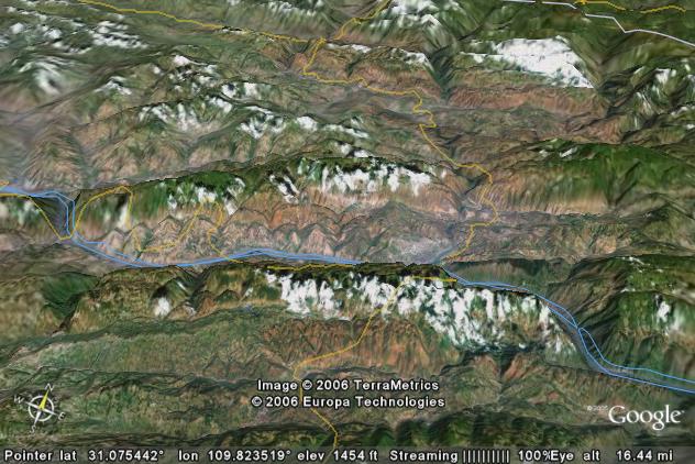
The highest mountain range in the world, 4 out of the 5 highest peaks in the world (all over 27,000 feet), and a river runs through it. (Actually there are several rivers that run through it, but we will only give a picture of one of them.) The picture below is a vertical view of the Himalayan Mountains. The bright yellow line marks the border between China (Tibet) to the north and Nepal to the south. A small piece of India can be seen in the lower right corner.
Mt. Everest at 29,035 feet is the highest mountain in the world. The summit is under the second “e” in the “Everest” label. Lhotse (label not shown) tops out at 27,940 feet and is just 2 miles to the southeast. Makalu at 27,766 feet is 12 miles east-southeast of Everest and is the 5th highest mountain in the world. Kanchenjunga at 28,169 is the third highest and can be found on the Nepal/India border in the lower right hand corner.
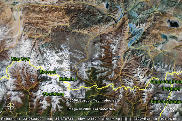
Water drainage from the slopes of Mount Everest is an interesting study in antecedence. Starting from the top of Mt. Everest, the Rongbuk Glacier flows 11 miles to the north-northwest into China. The Rongbuk Monastery is 16 miles NNW of Everest and can be reached by road from China. Melt water from the glacier becomes part of the headwaters for the Rong River.
22 miles north-northwest of Everest, the Rong River turns eastward. You can locate this point in the above picture by going NNW from Everest until you intersect a faint yellow road. The Rong River flows ENE and then ESE until it joins the Arun River some 33 miles northeast of Mt. Everest. (This is near the intersection of two local “roads” - faint yellow lines in the picture)
The Arun River flows nearly due south from this point. If you look closely, you can follow its path from the road intersection (above), across the China/Nepal border (the crest of the Himalayas), and through the “a” in “Europa”.
60 million years ago the Himalayan Mountains did not exist. The rock that would become Mt. Everest was 450 to 500 million year old sedimentary layers that were at or below sea level and somewhere well south of the current location of Mt. Everest. These sedimentary rocks contained fossils of trilobites, crinoids, and other animals that once lived in a much earlier ocean. What was then the southern coast of China was located somewhere near the northern border of present day India. The ancestor of the Arun River flowed southward over these lowlands.
Meanwhile, the subcontinent of India had rifted away from the east coast of Africa and was being rafted north-northeastward by convection currents in the upper part of the Earth’s mantle. Movement was a relatively rapid several inches per year.
The collision between India and China began about 50 million years ago. By 40 million years ago the intervening ocean was gone. The Indian subcontinent was plowing into China. The leading edge of the subcontinent had to go somewhere, and the most convenient direction was to dive under China. This extra buoyant material began to lift what had been the Chinese lowlands. The uplift of the Tibetan Plateau began.
The 450 to 500 million year old sedimentary rock that had been in-between India and China, including the Mt. Everest limestones and sandstones, also had to go somewhere. As these rocks were crumpled together, they broke into slabs, and then the slabs were pushed one on top of the other. In short, the only direction the sedimentary layers could go was up - bigtime up.
As the old sedimentary layers rose out of the ocean, the ancestral Arun River initially just extended its course further south out over the new land area. However, it wouldn’t be long before the Arun had to start eroding into the rising land mass if it was going to keep its southward course.
The Himalayan Mountain Range has been uplifted rapidly over the last 30 million years. What had been lowlands in southern China have been buoyed upward to over 15,000 feet to form the Tibetan Plateau. The Mt. Everest limestones/sandstones have been both buoyed upward and stacked (faulted slabs), and the old trilobites are now found at 29,000 feet above sea level.
The Arun River has cut downward into this rising mass (mess?) but not as fast as the land has been uplifted. It’s been: “uplift 2 feet”, “cut down 1 foot”, “uplift 2 feet”, “cut down 1 foot”, etc. However, the Arun’s erosion has been good enough for the river to maintain its course.
The Himalayan Mountains are still rising today. The Arun is still eroding down into this rising mountain mass. Today the Arun is cutting a steep gorge across the Himalayas. In all probability the Arun will win this contest, and millions of years from now it will have dug a canyon 10,000 or more feet deep across the Himalayas.
Further out in the future, the Himalayas will stop rising and erosion will begin to level them. Two hundred million years from now the Himalayas will be mere stumps, but the Arun River will be an old drainage system that cuts across these stumps. If you could take a “future” picture, it might look like the current “unknown tributary in the northern Ural Mountains”. (See the picture on the European page. http://www.durangobill.com/AncestralRivers/AncestralRiversEurope.html )
Euphrates River,
Syria
The Euphrates River originates in the mountains of Turkey, flows southward into Syria, and then turns east-southeast through eastern Syria and Iraq. Eastern Syria is a dry desert. Areas near the Euphrates have water available for irrigation, and the resulting vegetation shows up as dark areas. If water is not available, the land is dry sand and rock, and has a lighter color.
In the picture above, the Euphrates River is flowing from left to right through a mesa in eastern Syria. The low farmland both upstream and downstream from the mesa is about 700 feet above sea level while the mesa ranges from 1,000 feet to 1,150 feet. Information on the origin of the mesa is lacking, and the Google Earth image has relatively low resolution. Thus, its geologic history is not known and the following “eyeball analysis” by the author should be considered speculative.
It appears the mesa is the result of a series of recent fluidic lava flows. (The area apparently is not included in the USGS database of volcanoes, but there are some obvious cinder cones 30 miles to the WNW that are not included either.) If this conclusion is correct, then the mesa and the short canyon that the Euphrates has cut would be the result of the following sequence of events.
1) Five to ten million years ago the Euphrates River flowed through the valley. The mesa did not exist yet.
2) Sometime during the last few million years, volcanic eruptions of fluid lava covered the area that is now the mesa. These volcanic eruptions would form temporary dams across the river. The river would quickly overflow interim layers that were built up, and try to start cutting a canyon down through the mesa. However, subsequent eruptions and lava flows would fill in these initial attempts to cut a canyon, and leave a new flat surface.
3) The volcanic eruptions ended perhaps one to two million years ago (+/-). Since then the Euphrates has cut down through the mesa to generate its canyon. Ordinary erosion has also removed some of the surrounding terrain that was not protected by the hard lava layer. The steep sides of the canyon plus the fact that they have not eroded very far back from the river indicate that this has all been done very recently.
Indus River,
Pakistan
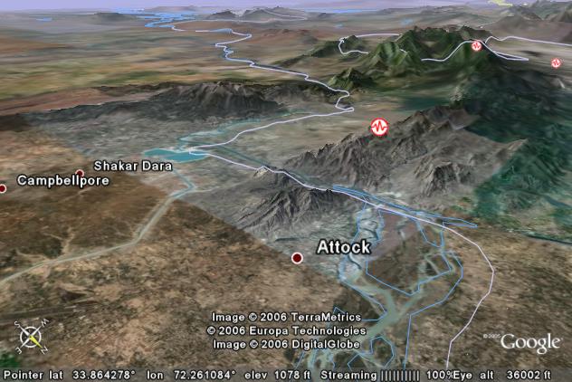
The picture above looks southwestward over the Indus River some 45 miles west-northwest of Islamabad, Pakistan. The Indus River enters the field of view from the lower edge and flows southwestward. This is another example of antecedence as the Indus was in place first, and the two ridges that it cuts through have been uplifted in the last few million years.
The Indus River looks like it is the result of two separate pieces. The lower half of the river flows south-southwestward from the Karakoram Mountains to the Indian Ocean. The headwaters section is somewhat similar to the Arun River in that it originates on the north side of the Himalayan Mountains in China. The headwaters drain about 20,000 sq. miles inside China (Tibet) before the river heads northwestward for 500 miles in what looks like a fault-aided, end run to get around the Himalayas. This implies that the Himalayas were in place first and the river drainage developed in response to Himalayan topography.
However, this course for the river takes it directly into the Karakoram Mountains including flowing within 60 miles of K2. K2 tops out at 28,250 feet above sea level making it the second highest mountain in the world. Thus, the headwaters of the Indus appear to be antecedent to the Karakoram Mountains. If we combine the two relative time sequences, we can conclude the Karakoram Mountains are younger than the main ranges of the Himalayas.
Jhelum River,
India controlled Kashmir
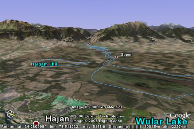
The picture above shows the Jhelum River, which is a tributary to the Indus River. All the preceding descriptions for the Himalayan and Karakoram Mountains again apply.
In the picture we see a flat valley at about 5,100 feet above sea level with towering mountains that rise above 13,000 feet in back of the valley. Does the river flow out of the mountains or does it flow into the mountains?
The Jhelum River was in place before the mountains were uplifted. As they rose the Jhelum was able to erode rock that kept getting in the way. We are looking downstream. The river flows into the mountains and cuts an 8,000 foot deep canyon in the process.
To give you some idea of the distances involved, it is 17 miles from the village of Hajan to the distant dot which marks the village of Baramula.
Selenge River,
Russia
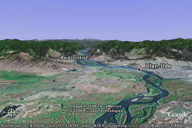
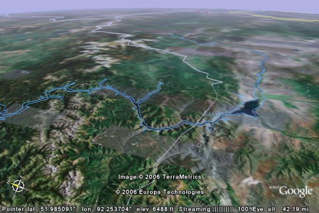
The Himalayas get all the attention when it comes to Asian mountain ranges, but there are other significant mountain ranges that are cut by major rivers. The picture above shows the Selenge River which is the largest river that flows into Russia’s Lake Baikal (Lake Baykal).
The river of course flows from the flatlands in the foreground through the mountains to reach Lake Baikal which is about 50 linear miles to the northwest of where the river enters the mountains.
The mountain range in the background is the Khamar-Daban. The highest peaks rise some 2,000 feet above the river.
Lake Baikal is of geologic interest as it is part of a rift system system in the middle of the Asian continent. As the rift spreads apart, Lake Baikal is getting bigger.
Sutlej River
& Bhakra Dam, India
The Sutlej River is still another river that starts on the north side of the Himalayas, and then flows south through the range. In its headwaters in China (Tibet) it’s known as the Xiangquan River. (Happiness is just looking up how to spell it - I don’t have to pronounce it.)
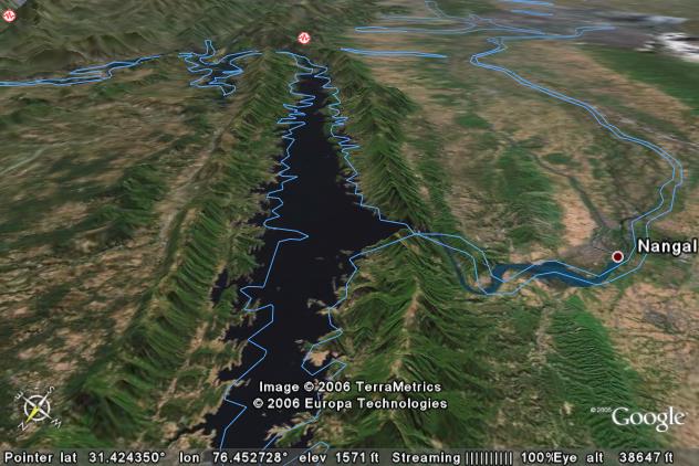
The picture above shows the reservoir behind the Bhakra Dam in the foothills of the Himalayas. The main ranges are off the left side of the picture. These low ridges are just in their initial stages of uplift. Perhaps in a few tens of millions of years, they will rival Mt. Everest.
The Sutlej River was of course here before the right ridge began to rise. (However, it looks like the rising ridges pushed it around a bit before it settled into its present course.) If you filled in the gap where the dam is located, the river could make an end run off the lower edge of the picture and find a 500-foot lower escape route. However, when the ridge began to rise, the Sutlej was able to erode down through the rising ridge and thus today, it takes the illogical route.
Where a river cuts through a ridge as in the above picture, it makes an ideal place to build a hydroelectric dam. The dam itself is 741 feet high which is slightly higher than the Hoover Dam on the Arizona/Nevada border.
Tigris River,
Iraq
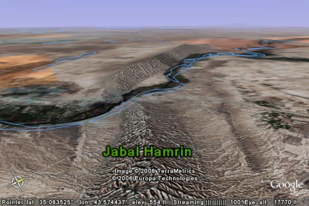
The picture above shows the Tigris River where it diagonally cuts though the Jabal Hamrin mountain ridge in northern Iraq. Very little is known about the uplift history other than what can be seen in the picture. The ridge rises about 1,000 feet above the river.
The small amount of detail that can be seen via Google Earth shows that the ridge is composed of tilted layers of sedimentary rock. It is also about 55 miles west-southwest of Kirkuk and its associated oilfields. There are similar NW-SE trending ridges that extend through the oilfields area. Thus, it is assumed that the Jabal Hamrin ridge is part of the same system, and probably dates back over 50 million years.
Yangtze River,
China (2 pictures)
China has probably the most widespread ongoing geologic activity in Asia. The downside of this is that they have had many devastating earthquakes that have killed thousands of people.
There are multiple areas in China where rivers cut through mountain systems instead of going around them. We will only concentrate on one river, the Yangtze, but will use two pictures.
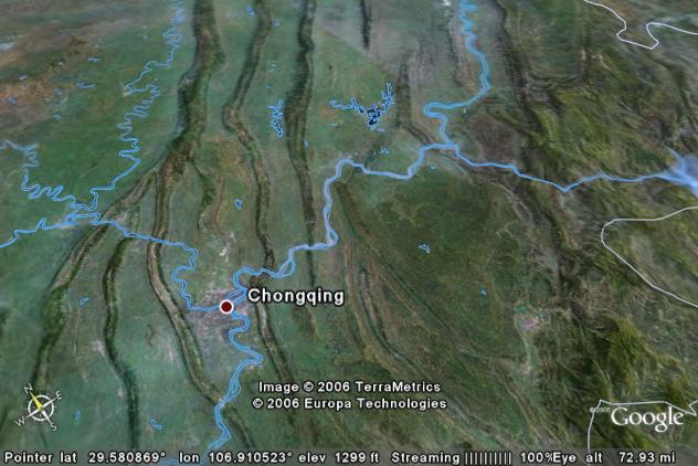
The picture above shows the Yangtze River and some of its tributaries in central China. The Yangtze enters from the lower edge and flows northeastward off the right portion of the top edge. Three major tributaries join at left (the Fu, Jialing, and Qu) and the combination joins the Yangtze. The Wu joins from the right.
Of interest are the ridges that are cut by these rivers. The ridges rise anywhere from 500 to 1,500 feet above the river systems. They look remarkably similar to the river/ridge systems in the northeastern United States. (See Ancestral Rivers of the Eastern United States). While very little is known about the uplifted history here in China, the similarity suggests that this also an example of antecedence.
The Wu (enters from the right) and is no slouch as it cuts across upturned sedimentary ridges to produce a 4,000-foot deep canyon just inside the right edge. What will be of even more interest will be the Yangtze (in the next picture) when it cuts to the right, from the lowlands, back into these high ridges.
Actual river elevations and the areas between the ridges typically run between 500 and 1,000 feet above sea level. The horizontal extent of the picture spans about 120 miles from the bottom edge to the top edge. Keep these dimensions in mind as you view the next picture.
The picture above is another view of the Yangtze, but this is further downstream in the famous Yangtze Gorges. (The Three Gorges Dam is about 60 linear miles downstream and off the right edge.) The Yangtze is cutting across ridge systems that range from 4,000 to 6,000 feet above sea level. At the right cut, the mountain rises abruptly more than a mile above the river.
The Daning River is a tributary to the Yangtze. It enters from the top edge (right of center) and flows south-southeastward to join the Yangtze. It has also cut through the ridge to form its own little gorge that is several thousand feet deep.
The uplift history in this area is not known. However, given the magnitude involved, it is probable that this area of the Yangtze is an example of antecedence. The river and its tributaries were here first, and the mountains were uplifted later. The Yangtze has had enough erosion power to abrade away the mountains as they rose. It is probable that the historical elevation of the Yangtze has not changed much. The contrary argument that the Yangtze started at an elevation equal to the current tops of the mountains would have to account for the huge upstream land area that is currently below 1,000 feet.
Yenisey River,
Russia
The final river that we will look at is the Yenisey River in Russia. There are many more examples of rivers in Asia that cut through mountain ranges instead of finding some other easier route, but there is a limit to what we can reasonably look at.
The picture above shows the remote Sayan Mountains in southern Russia. The crest of the range typically runs between 6,000 and 8,000 feet. The lowlands to the right of the range are 1,700 to 1,800 feet. And of course the Yenisey River flows from right to left across the mountain range.
The Yenisey is the fifth longest river in the world and one of the major rivers of Siberian Russia. Some 2,000 miles off the left edge of the picture, it empties into the Arctic Ocean.
The large lake that can be seen to the right of the mountains is the upstream end of the large reservoir that has backed up behind the Sayano-Shushenskaya Dam (various spellings) which is off the left side of the picture. The reservoir backs up all the way through the mountains.
The uplift history of the Sayan Mountains is not known. Erosional patterns indicate the mountains have been subject to erosion for perhaps 50 million years. Google Earth doesn’t show recent earthquakes in the area, but other sources do show earthquake activity. Some recent uplift appears to be continuing. It is obvious that the Yenisey River was in place first before the mountains were uplifted. Thus this is another example of antecedence.
Return to main Ancestral Rivers Page
Web page generated via Sea Monkey's Composer
within a Linux Cinnamon Mint 18 operating system.
(Goodbye Microsoft)