
Durango Bill's
Paleogeography (Historical Geology) Research
The Little
Colorado River
Junction of the Little Colorado River and the Colorado
Grand Falls of the Little Colorado River
Junction of the Little Colorado River and the Colorado
Grand Falls of the Little Colorado River
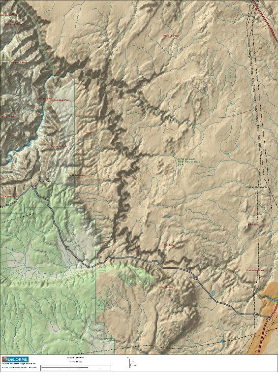 The relief/topo map at
the right shows the junction of the Little Colorado River and
the Colorado River just to the east of the main portion of
Grand Canyon National Park. The Colorado River enters from the
upper left corner and flows south and southwestward to exit
off the left edge. The Little Colorado River enters from the
lower right edge and flows generally north and northwestward
to join the Colorado River in the upper left quadrant. Note
that the two rivers flow in opposite directions for a
considerable distance - a point that we will come back to.
The relief/topo map at
the right shows the junction of the Little Colorado River and
the Colorado River just to the east of the main portion of
Grand Canyon National Park. The Colorado River enters from the
upper left corner and flows south and southwestward to exit
off the left edge. The Little Colorado River enters from the
lower right edge and flows generally north and northwestward
to join the Colorado River in the upper left quadrant. Note
that the two rivers flow in opposite directions for a
considerable distance - a point that we will come back to.Short sections of U. S. highway # 89 (red road) can be seen in the right corners while Arizona highway # 64 (the east entrance to Grand Canyon National Park) can be seen across the lower half of the map. Cameron, Arizona is in the lower right corner.
The Little Colorado River is of interest as it has played a part in both the oldest and most recent derivation of the Colorado River drainage system. Before the Rocky Mountains first began to rise some 70 million years ago, river drainage was from southwest to northeast across this area. As the Rockies rose they blocked the southwest to northeast drainage, and the ancestral Little Colorado drainage was established. Since this drainage could not go through the rising Rockies, the Little Colorado established an “end run” around the Rockies.
Here in Arizona, the initial drainage was from southeast to northwest (essentially what we see now and continuing northwestward across what would become the Kaibab Plateau), then north through south-central and eastern Utah, and finally northeastward through northwestern Colorado and on into present day Wyoming. The first uplift of the Kaibab began shortly after this ancestral river route was established. Part of this initial route of the Little Colorado would be reused by the Colorado in subsequent events when the Colorado would eventually relocate to Arizona tens of millions of years later.
40 million years ago, there was a second uplift of the Kaibab Plateau which forced the Little Colorado to relocate further to the east, but the ancestral path of the Little Colorado would leave a relatively low route across the Kaibab.
If we keep following the clock forward, by 15 million years ago, the lower right portion of the map area (and for a considerable distance off the lower right edge) had subsided into a closed basin with little if any outward drainage. It was basically a “playa” that would hold a shallow lake during wet periods, but would be dry much of the time. At one time it was theorized that a large lake (Hopi Lake) occupied the area, but recent evidence shows that no large lake ever existed here. (If nothing else, the climate is too dry.)
In the last few million years, as the climate has cooled and precipitation has increased, the Little Colorado River has once again become a contributor to the Colorado River system. The current path of the Little Colorado gives us some clues as to what happened to local topography and when it happened.
The Hopi Butte Volcanic field (well off the lower right edge of the map) was active 5.5 million years ago when the Colorado River abandoned its route across Utah (in response to uplift of the Wasatch Plateau) and established a new route over the ancestral low route across the Kaibab. In the Hopi Butte volcanic field, there are dikes and sills below about 6,300 feet elevation but surface lava flows and volcanic ash above 6,300 feet. This tells us that 5.5 million years ago the ground surface not to far from the map area was near 6,300 feet above sea level.
Current elevations in the map area range from:
1) Over 7,000 feet on the Kaibab Plateau in the lower left corner;
2) Down to 6,000 to 7,000 feet in between the Little Colorado and Colorado Rivers;
3) Down to below 4,200 feet in the lower right corner;
4) Down to about 2,700 feet in the bottom of the Grand Canyon.
When the Colorado River established its current course, the most recent uplift of the Kaibab Plateau hadn’t begun yet as the path of the Colorado doesn’t show any deflection to avoid the Kaibab. Thus 5.5 million years ago there was a nearly level surface at about 6,300 feet (level with the Hopi Butte Volcanic Field) that led into the ancestral low area across the Kaibab.
The Little Colorado River is deflected by the Kaibab as it turns north before turning west to join the Colorado. It also flows parallel to the topographic contours. The slope is down to the right and up to the left. We thus get the following sequence of events:
1) 5.5 million years ago the Colorado River relocated to Arizona. It was not deflected by the Kaibab, and side erosion began to develop side canyons into the Colorado.
2) The Kaibab Plateau began its most recent uplift. The Colorado River became entrenched and started to cut the Grand Canyon.
3) On the order of one to two million years after the Colorado River became established, rainfall in the local area increased to the point that the Little Colorado River could overflow its basin. However, the Kaibab had risen somewhat with the result that the Little Colorado was deflected further north around the east side of the Kaibab until it could connect with a side canyon leading into the main Colorado.
4) As the Kaibab continued to rise (about 1,400 feet over the last 5.5 million years) both rivers have cut deep canyons into the rising terrain. The very steep sides to the Little Colorado Gorge attest to very young erosion.
Grand Falls
of the Little Colorado River
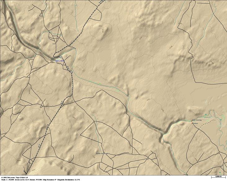
Before it gets close to the Colorado River, most of the Little Colorado’s path across Arizona crosses very flat land. However the relief map shows a couple of areas of interest. Contour lines at 50 foot intervals show a small canyon complex in the lower right portion of the map, and a deeper canyon in the upper left.
This area is just to the east of the Sunset Crater/San Francisco Peaks volcanic field. Sunset Crater erupted just a thousand years ago, and there are many dozens of other nearby cinder cones and basaltic lava flows of recent origin. The volcanic field sits on top of a hot spot where magma is rising from deep under the earth’s crust.
Magma from the volcanic field manifests itself in two phenomena:
1) The magma can intrude between in rock layers below the surface. An intrusion acts like a blood blister and lifts the rock layers above it.
2) The magma can rise to the surface to produce a volcanic eruption. This can include lava flows as well as cinder cones.
The canyons that can be seen in the relief map are the result of uplifts over intrusions. When surface rock is uplifted, it becomes an obstacle to any river system than runs through the uplift. River and stream systems carry mud and sand, and these particles can abrade anything that “gets in their way”. The canyons that can be seen in the map are the result of thousands of years of abrasion by the Little Colorado River and some of its tributaries.
The upper left canyon shows the next step in the process. Initially, the Little Colorado River abraded a canyon several hundred feet deep by the above process. The next thing that happened was a surface lava flow.
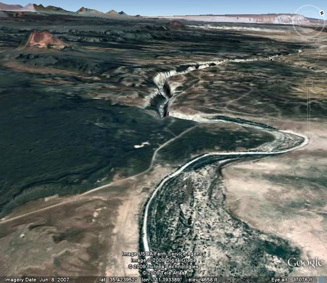
The Google Earth picture above shows what happened after a lava flow entered from the left side of the picture. (About 20,000 years ago http://bulletin.geoscienceworld.org/cgi/content/abstract/118/3-4/421) The lava flow filled in part of the canyon and then continued some three-quarters of a mile to the northeast of the old canyon. Mud and silt have filled in the old upstream side of the canyon (foreground in the picture) while the river has been diverted around the lava flow. The river bed returns to the older canyon on the far side of the lava flow. When the Little Colorado River does flow, it forms a waterfall where it pours over the edge of the older canyon.
Return to the Image Index Page
Web page generated via Sea Monkey's Composer HTML editor
within a Linux Cinnamon Mint 18 operating system.
(Goodbye Microsoft)