
Durango Bill's
Paleogeography (Historical Geology) Research
Flaming Gorge and the Eastern Uinta Mountains, Utah
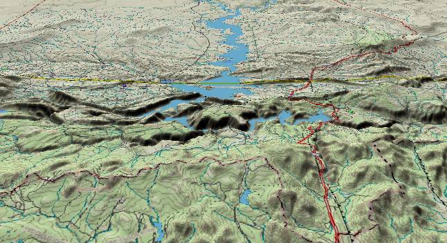
Contour lines at
100-foot intervals. On the north side of the eastern Uinta
Mountains, the Green River is dammed in Flaming Gorge to
produce Flaming Gorge Reservoir. Strata here dip down steeply
to the north with several east-to-west hogback ridges visible
in the top half of the picture. The 7,700-foot flat plateaus
(Dowd Mountain and Bare Top Mountain) that bracket the steep
narrow gorge (just left of the center of the picture) are
remnants of an ancient erosion surface that has been uplifted
in recent times. U. S. Highway 191 runs from south to north
through the range at the right and follows Cart Creek down the
north side. Cart Creek flows from south to north through the
highest part of the range and had to be in place before the
crest was lifted to its present height.
The primary uplift of the Uinta Mountains took place during the early Tertiary. Then erosion set in, and debris (the Bishop Conglomerate) was deposited on both the north and south facing slopes of the mountains. Sometime in mid to late Miocene time, drainage that had been flowing northeastward out of the Green River Basin was blocked by renewed uplift in the Wind River Range. Drainage turned southward to form the present Green River. When this new river reached the Uintas, it turned eastward around the east end of the mountains. The flat surface represented by Dowd and Bare Top Mountains had to be much lower at that time. Otherwise the Green River would have flowed eastward from Rock Springs, Wyoming. (Current topographic maps show you can go east from Rock Springs to the N. Platte River and never exceed 6,950 feet.)
The Colorado River overflowed the Kanab Plateau about 5.4 million years ago. When canyon cutting worked its way back upstream, the Green River became entrenched in its current location. Finally, a second uplift of the eastern Uintas (including Dowd and Bare Top Mountains) has occurred in the last few million years. This uplift had to be most pronounced on the north side of the range (the current crest) and less to the south. Both Cart Creek and Crouse Creek (further east - not in the picture) flow south to north through the range as remnants of a former drainage pattern.
Return to the Image Index page
Web page generated via Sea Monkey's Composer HTML editor
within a Linux Cinnamon Mint 18 operating system.
(Goodbye Microsoft)