
Durango Bill's
Paleogeography (Historical Geology) Research
Origin and Formation of the
Black Canyon of the Gunnison River, Colorado
The view below shows
the northwest end of the Black Canyon of the Gunnison River.
Contour intervals are 100 feet. The south rim visitor area of
Black Canyon National Park is just above the center of the
lower edge. The river flows northwestward through the high
plateau ignoring an easier route toward the southwest (left
edge).
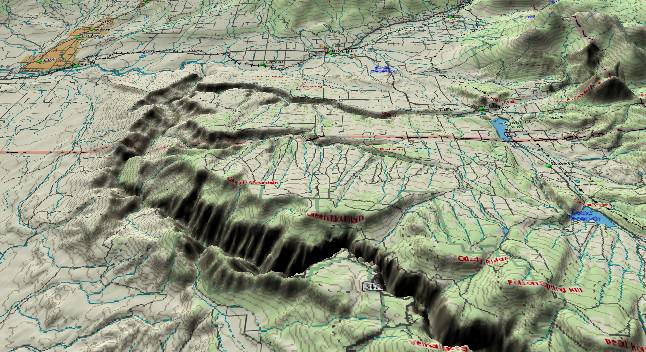
In the distance, the Smith Fork River originates in the West Elk Mountains (off the right edge of the picture) and flows westward (toward the left) just north of the northernmost lake to eventually join the Gunnison River. This is parallel to the contour lines and thus ignores today's topographic (and stratigraphic) slope, which tilts down toward the north.
A little closer (near the county boundary), Red Canyon also cuts east to west to enter the Gunnison. It too ignores the topographic and stratigraphic tilt. Both of these rivers reflect ancestral topography when downhill was toward the left (west) instead of today's downhill toward the north.
Red Rock Canyon starts at the lower edge (left of center) and continues north through the high ridge on the south side of the Black Canyon to join the Gunnison. This high rim is on the upthrown side of the Cimarron Fault. The Cimarron Fault parallels the left edge of the picture (and then curves southeastward to the lower edge) and vertical displacement on the fault separates the lowlands to the west from the high plateau that the Gunnison River has sliced through to form the canyon. Near the left edge, an abandoned canyon also cuts from south to north through the ridge. This canyon is dry now, but at some point in the past there was a tributary stream here. Both of these canyons are remnants of an ancestral topography that existed before the Cimarron Fault was active. In the earlier time period, the plateau had not been uplifted yet; hence there was no barrier to northward flowing streams.
The picture below shows the southeast end of the Black Canyon with contour intervals again at 100 feet. The south rim visitor area of Black Canyon National Park is near the left edge of the picture while a portion of the West Elk Mountains can be seen in the upper right quadrant.
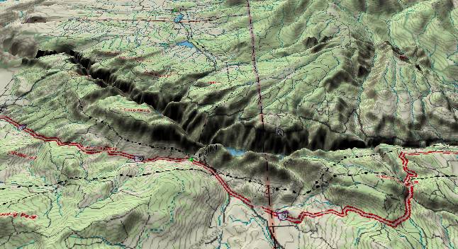
Near the lower edge of the picture there are four interesting breaches of the high south rim. The westernmost of these is another abandoned canyon between the visitor area and Poverty Mesa. Hairpin Creek (lower left corner) probably continued northward through this old canyon at some point in the past.
Further east (to the right) the Cimarron River cuts through Cimarron Ridge (upthrown side of the fault) from south to north at Cimarron (a short distance west of the boundary between Montrose and Gunnison counties). Just to the east of the county line, an abandoned high valley cuts across the ridge. In the not too distant past, the Little Cimarron River formerly crossed the ridge here, but subsequently it found an easier route by taking a more westerly course to join the Cimarron River on the south side of the ridge. Thus, the old breach was abandoned. Finally, Blue Creek forms another south to north breach through the ridge at the extreme lower right corner.
Crystal Creek is also of interest. It originates in the West Elk Mountains and flows southwestward across the county line to join the Gunnison in the Black Canyon. The lower end of this path is significant as it is stratigraphically (and smoothed topographically) uphill. If the stream path followed today's topography, it would turn north to follow the downward tilt toward the top of the picture (through the two lakes).
The standard geologic explanation for the formation and origin of the canyon assumes the strata layers have been static since early Tertiary time (at least 50 million years ago). In this standard scenario, the entire area was covered with softer sedimentary layers and the Gunnison established a route across the top of these layers. Then it started to cut down through these layers and became entrenched in its present course. Further downcutting then formed the canyon. While, this sequence has been accepted for many years, it ignores an impossible contradiction - thus another explanation is required.
The contradiction is a result of the high plateaus the river cuts through (west of the county line in the "southeast" view above) vs. multiple Oligocene and Miocene volcanic tuff deposits that virtually surround the town of Gunnison a few miles upstream (off the right edge of the picture). The high plateaus (west of the county line) exceed 9,000 feet above sea level. Dakota Sandstone surfaces these on the north rim and much older Precambrian rock on the south rim. If the strata for these plateaus had been static, then the river originally would have to be at least 9,000 feet above sea level when it first established a route across this surface, and higher still if there were any deposits on top of these layers. More important, the entire river basin upstream from this point would also have to be above 9,000 feet until after the canyon was cut.
If we go upstream from the Black Canyon to the town of Gunnison, we descend to 7,700 feet. Gunnison is virtually surrounded by Oligocene and Miocene volcanic ash (tuff and welded tuff) that can be found down to the 8,000-foot level. This is material that fell from the air to an exposed ground surface some 20 to 30 million years ago. The important part is the 8,000-foot marker. As noted above, the high plateaus would force all upstream elevations to exceed 9,000 feet until after the canyon was cut. Yet the volcanic tuff deposits require an upstream exposed surface at 8,000 feet. Thus, the high plateaus had to be much lower when the volcanic ash was deposited so that erosion could produce an exposed surface at 8,000 feet. Hence, the high plateaus are not static. They were not uplifted until recently. We thus present the following sequence that seems to be a better explanation for the origin of the Black Canyon.
The first step is to look at the canyon to see if this gives any clues to its age. The most impressive feature of the canyon is its extreme depth relative to its width. At the Narrows it is 1750 feet deep and only 1300 feet wide. (Roadside Geology of Colorado - page 282.) This depth to width ratio of 1.35 is greater than that of any other canyon in the Colorado River system. (2nd place goes to the Little Colorado River where it cuts through the K-T Limestone. If you just consider the inner gorge portion of the Grand Canyon, the Muav Gorge section between Kanab Creek and the Toroweap Fault ties for second.)
Thus the depth/width ratio is greater than any section of the Grand Canyon. The ratio is nearly three times greater than the 0.5 depth-to-width ratio where U.S. highway 89 spans Glen Canyon just below Glen Canyon Dam. This is even more remarkable as the canyon walls in Black Canyon are subject to much greater weathering (including ice wedging) than conditions in the Grand Canyon.
All of the other canyons in the Colorado River system that have large depth to width ratios are young. Most have been carved since the Colorado River found an escape route across the Kaibab Plateau 5.4 million years ago. Thus the extreme depth to width ratio of the Black Canyon requires that the Black Canyon is young - very young. It has taken at most (and probably less than) 5.4 million years to cut the 2,000-foot depth from today's rim to the canyon floor.
At the end of the "Standard Explanation" section we noted the high plateau north of the Cimarron Fault had to be lower at some time in the past. It appears that activity along this fault has lifted the plateaus some 3,000 feet in the last 5 million years. Thus 5 million years ago, the plateaus were 3,000 feet lower. (Note, USGS earthquake records show a small amount of activity near and south of the Cimarron Fault, but the required rate of uplift implies greater seismic activity should exist. Either the rate of uplift has moderated recently or the last few decades are merely a temporary lull in earthquake activity. The steep gradient of the Gunnison River in the canyon favors the temporary lull option.)
Now that we have determined the age of the Black Canyon, we'll go back to the early Tertiary (Paleocene and Eocene time) before the West Elk Mountains, or the Cimarron Fault (and the Black Canyon Plateaus) existed to give the whole history of the canyon. The ancestral Gunnison River originally formed in the late Cretaceous / early Tertiary. To the east of the present town of Gunnison, the drainage pattern for the river was essentially the same as it is now. However, from Gunnison, the river continued west across the present location of the West Elk Mountains, and then turned more northward toward the Lake Uinta lowlands.
In the late Oligocene (about 30 million years ago) volcanic activity broke out to create today's West Elk Mountains. The old path of the Gunnison across this area was blocked, and it was forced to make an end run around the south side of the West Elk Mountains until it could get far enough west to turn north again. Then, during early Miocene time, all the major rivers west of the Continental Divide turned west to flow into Utah. The ancestral Gunnison was part of this pattern and took a more westerly course (than it does now) to join the Colorado River at the east end of Unaweep Canyon.
By about 6 million years ago the Gunnison abandoned the Unaweep Canyon route to approximate its current course. The exact path is unknown as the entire present valley north to Grand Junction was part of a large flat valley system. By 5.4 million years ago, at least the northwest portion of today's canyon was covered by an extensive silt backup system as the rising Wasatch Ranges in Utah blocked the former westward escape route of the Colorado River.
Tributary streams that were the ancestors of today’s Smith Fork, Red Canyon, and Crystal Creek flowed westward from the West Elk Mountains. On the southwest side of the Gunnison River, other tributaries flowed northward to join the Gunnison. The Cimarron Fault had not become active yet and today's high Gunnison Plateau was still at low elevations. Thus, there was no obstruction to this northward flow.
After volcanic activity in the West Elk Mountains came to an end, the magma pool that had been feeding the eruptions subsided somewhat. This displacement initiated the Cimarron Fault causing the surface to drop on the northeast side of the fault, and leaving a small scarp (higher area) on the southwest side. The ancestral Gunnison River settled into its current path along the base (northeast side) of this scarp.
About 5.4 million years ago the Colorado River found a new route across Arizona's Kaibab Plateau and started digging the Grand Canyon. As exit elevations for the Colorado River Basin were lowered, canyon cutting and erosion worked back upstream. When this activity got to the Gunnison Plateau / Black Canyon area, all the major rivers and streams in the area became entrenched.
The uplift phase on the northeast side of the Cimarron Fault began at some point after all the rivers and streams were entrenched. The Gunnison Plateau was subsequently lifted to its present elevation. On the northeast side of the river (extending toward the West Elk Mountains) this uplift produced today's northward tilt. However, the old streams coming down from the West Elk Mountains were entrenched and to this day still maintain their old westward courses.
On the southwest side of the Gunnison River, uplift on the northeast side of the Cimarron Fault presented a problem for all the tributaries coming in from the south. Those rivers and streams that had enough erosion power were able to cut down through the rising block. The streams that had less erosive ability eventually abandoned their old paths.
Finally, the Gunnison itself is a big river. It was even bigger during the ice ages and was carrying a lot of glacial silt. The hardest Precambrian rock was no match for this abrasive power. While the plateau rose, the river acted as a stationary band saw and cut the canyon.
Return to the Image Index page
Web page generated via Sea Monkey's Composer
within a Linux Cinnamon Mint 18 operating system.
(Goodbye Microsoft)
In the distance, the Smith Fork River originates in the West Elk Mountains (off the right edge of the picture) and flows westward (toward the left) just north of the northernmost lake to eventually join the Gunnison River. This is parallel to the contour lines and thus ignores today's topographic (and stratigraphic) slope, which tilts down toward the north.
A little closer (near the county boundary), Red Canyon also cuts east to west to enter the Gunnison. It too ignores the topographic and stratigraphic tilt. Both of these rivers reflect ancestral topography when downhill was toward the left (west) instead of today's downhill toward the north.
Red Rock Canyon starts at the lower edge (left of center) and continues north through the high ridge on the south side of the Black Canyon to join the Gunnison. This high rim is on the upthrown side of the Cimarron Fault. The Cimarron Fault parallels the left edge of the picture (and then curves southeastward to the lower edge) and vertical displacement on the fault separates the lowlands to the west from the high plateau that the Gunnison River has sliced through to form the canyon. Near the left edge, an abandoned canyon also cuts from south to north through the ridge. This canyon is dry now, but at some point in the past there was a tributary stream here. Both of these canyons are remnants of an ancestral topography that existed before the Cimarron Fault was active. In the earlier time period, the plateau had not been uplifted yet; hence there was no barrier to northward flowing streams.
The picture below shows the southeast end of the Black Canyon with contour intervals again at 100 feet. The south rim visitor area of Black Canyon National Park is near the left edge of the picture while a portion of the West Elk Mountains can be seen in the upper right quadrant.
Near the lower edge of the picture there are four interesting breaches of the high south rim. The westernmost of these is another abandoned canyon between the visitor area and Poverty Mesa. Hairpin Creek (lower left corner) probably continued northward through this old canyon at some point in the past.
Further east (to the right) the Cimarron River cuts through Cimarron Ridge (upthrown side of the fault) from south to north at Cimarron (a short distance west of the boundary between Montrose and Gunnison counties). Just to the east of the county line, an abandoned high valley cuts across the ridge. In the not too distant past, the Little Cimarron River formerly crossed the ridge here, but subsequently it found an easier route by taking a more westerly course to join the Cimarron River on the south side of the ridge. Thus, the old breach was abandoned. Finally, Blue Creek forms another south to north breach through the ridge at the extreme lower right corner.
Crystal Creek is also of interest. It originates in the West Elk Mountains and flows southwestward across the county line to join the Gunnison in the Black Canyon. The lower end of this path is significant as it is stratigraphically (and smoothed topographically) uphill. If the stream path followed today's topography, it would turn north to follow the downward tilt toward the top of the picture (through the two lakes).
Standard
Explanation for the Origin of the Black Canyon
The standard geologic explanation for the formation and origin of the canyon assumes the strata layers have been static since early Tertiary time (at least 50 million years ago). In this standard scenario, the entire area was covered with softer sedimentary layers and the Gunnison established a route across the top of these layers. Then it started to cut down through these layers and became entrenched in its present course. Further downcutting then formed the canyon. While, this sequence has been accepted for many years, it ignores an impossible contradiction - thus another explanation is required.
The contradiction is a result of the high plateaus the river cuts through (west of the county line in the "southeast" view above) vs. multiple Oligocene and Miocene volcanic tuff deposits that virtually surround the town of Gunnison a few miles upstream (off the right edge of the picture). The high plateaus (west of the county line) exceed 9,000 feet above sea level. Dakota Sandstone surfaces these on the north rim and much older Precambrian rock on the south rim. If the strata for these plateaus had been static, then the river originally would have to be at least 9,000 feet above sea level when it first established a route across this surface, and higher still if there were any deposits on top of these layers. More important, the entire river basin upstream from this point would also have to be above 9,000 feet until after the canyon was cut.
If we go upstream from the Black Canyon to the town of Gunnison, we descend to 7,700 feet. Gunnison is virtually surrounded by Oligocene and Miocene volcanic ash (tuff and welded tuff) that can be found down to the 8,000-foot level. This is material that fell from the air to an exposed ground surface some 20 to 30 million years ago. The important part is the 8,000-foot marker. As noted above, the high plateaus would force all upstream elevations to exceed 9,000 feet until after the canyon was cut. Yet the volcanic tuff deposits require an upstream exposed surface at 8,000 feet. Thus, the high plateaus had to be much lower when the volcanic ash was deposited so that erosion could produce an exposed surface at 8,000 feet. Hence, the high plateaus are not static. They were not uplifted until recently. We thus present the following sequence that seems to be a better explanation for the origin of the Black Canyon.
Formation and
Origin of the Black Canyon
The first step is to look at the canyon to see if this gives any clues to its age. The most impressive feature of the canyon is its extreme depth relative to its width. At the Narrows it is 1750 feet deep and only 1300 feet wide. (Roadside Geology of Colorado - page 282.) This depth to width ratio of 1.35 is greater than that of any other canyon in the Colorado River system. (2nd place goes to the Little Colorado River where it cuts through the K-T Limestone. If you just consider the inner gorge portion of the Grand Canyon, the Muav Gorge section between Kanab Creek and the Toroweap Fault ties for second.)
Thus the depth/width ratio is greater than any section of the Grand Canyon. The ratio is nearly three times greater than the 0.5 depth-to-width ratio where U.S. highway 89 spans Glen Canyon just below Glen Canyon Dam. This is even more remarkable as the canyon walls in Black Canyon are subject to much greater weathering (including ice wedging) than conditions in the Grand Canyon.
All of the other canyons in the Colorado River system that have large depth to width ratios are young. Most have been carved since the Colorado River found an escape route across the Kaibab Plateau 5.4 million years ago. Thus the extreme depth to width ratio of the Black Canyon requires that the Black Canyon is young - very young. It has taken at most (and probably less than) 5.4 million years to cut the 2,000-foot depth from today's rim to the canyon floor.
At the end of the "Standard Explanation" section we noted the high plateau north of the Cimarron Fault had to be lower at some time in the past. It appears that activity along this fault has lifted the plateaus some 3,000 feet in the last 5 million years. Thus 5 million years ago, the plateaus were 3,000 feet lower. (Note, USGS earthquake records show a small amount of activity near and south of the Cimarron Fault, but the required rate of uplift implies greater seismic activity should exist. Either the rate of uplift has moderated recently or the last few decades are merely a temporary lull in earthquake activity. The steep gradient of the Gunnison River in the canyon favors the temporary lull option.)
Now that we have determined the age of the Black Canyon, we'll go back to the early Tertiary (Paleocene and Eocene time) before the West Elk Mountains, or the Cimarron Fault (and the Black Canyon Plateaus) existed to give the whole history of the canyon. The ancestral Gunnison River originally formed in the late Cretaceous / early Tertiary. To the east of the present town of Gunnison, the drainage pattern for the river was essentially the same as it is now. However, from Gunnison, the river continued west across the present location of the West Elk Mountains, and then turned more northward toward the Lake Uinta lowlands.
In the late Oligocene (about 30 million years ago) volcanic activity broke out to create today's West Elk Mountains. The old path of the Gunnison across this area was blocked, and it was forced to make an end run around the south side of the West Elk Mountains until it could get far enough west to turn north again. Then, during early Miocene time, all the major rivers west of the Continental Divide turned west to flow into Utah. The ancestral Gunnison was part of this pattern and took a more westerly course (than it does now) to join the Colorado River at the east end of Unaweep Canyon.
By about 6 million years ago the Gunnison abandoned the Unaweep Canyon route to approximate its current course. The exact path is unknown as the entire present valley north to Grand Junction was part of a large flat valley system. By 5.4 million years ago, at least the northwest portion of today's canyon was covered by an extensive silt backup system as the rising Wasatch Ranges in Utah blocked the former westward escape route of the Colorado River.
Tributary streams that were the ancestors of today’s Smith Fork, Red Canyon, and Crystal Creek flowed westward from the West Elk Mountains. On the southwest side of the Gunnison River, other tributaries flowed northward to join the Gunnison. The Cimarron Fault had not become active yet and today's high Gunnison Plateau was still at low elevations. Thus, there was no obstruction to this northward flow.
After volcanic activity in the West Elk Mountains came to an end, the magma pool that had been feeding the eruptions subsided somewhat. This displacement initiated the Cimarron Fault causing the surface to drop on the northeast side of the fault, and leaving a small scarp (higher area) on the southwest side. The ancestral Gunnison River settled into its current path along the base (northeast side) of this scarp.
About 5.4 million years ago the Colorado River found a new route across Arizona's Kaibab Plateau and started digging the Grand Canyon. As exit elevations for the Colorado River Basin were lowered, canyon cutting and erosion worked back upstream. When this activity got to the Gunnison Plateau / Black Canyon area, all the major rivers and streams in the area became entrenched.
The uplift phase on the northeast side of the Cimarron Fault began at some point after all the rivers and streams were entrenched. The Gunnison Plateau was subsequently lifted to its present elevation. On the northeast side of the river (extending toward the West Elk Mountains) this uplift produced today's northward tilt. However, the old streams coming down from the West Elk Mountains were entrenched and to this day still maintain their old westward courses.
On the southwest side of the Gunnison River, uplift on the northeast side of the Cimarron Fault presented a problem for all the tributaries coming in from the south. Those rivers and streams that had enough erosion power were able to cut down through the rising block. The streams that had less erosive ability eventually abandoned their old paths.
Finally, the Gunnison itself is a big river. It was even bigger during the ice ages and was carrying a lot of glacial silt. The hardest Precambrian rock was no match for this abrasive power. While the plateau rose, the river acted as a stationary band saw and cut the canyon.
Return to the Image Index page
Web page generated via Sea Monkey's Composer
within a Linux Cinnamon Mint 18 operating system.
(Goodbye Microsoft)