
Durango Bill's
Paleogeography
(Historical Geology) Research
Origin of the "Barbed Tributaries" in the Marble Canyon section of the Grand Canyon
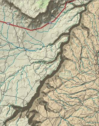 The topographic map at the
right shows part of the Marble Canyon section of the Grand
Canyon. Contour lines equal 100 feet. The Colorado River flows
from NNE (Mile 11) to SSW (Mile 32). On the west side of the
river there are four major tributary canyons (and a couple
more minor ones) that flow from WSW to ENE. In north to south
order these are, Soap Creek, House Rock, North Canyon, and
South Canyon. These arroyos flow "against the grain" with
respect to the direction that the Colorado River is flowing.
The result gives a "barbed" appearance to these arroyo
canyons. What is the origin of these barbed tributaries?
The topographic map at the
right shows part of the Marble Canyon section of the Grand
Canyon. Contour lines equal 100 feet. The Colorado River flows
from NNE (Mile 11) to SSW (Mile 32). On the west side of the
river there are four major tributary canyons (and a couple
more minor ones) that flow from WSW to ENE. In north to south
order these are, Soap Creek, House Rock, North Canyon, and
South Canyon. These arroyos flow "against the grain" with
respect to the direction that the Colorado River is flowing.
The result gives a "barbed" appearance to these arroyo
canyons. What is the origin of these barbed tributaries?
If we measure the length of these arroyo canyons (using a "start" marker where they first obtain a depth of 500 feet below the Kaibab Limestone surface), we note that South Canyon (at the south end) is about 4 miles long. North Canyon and House Rock are about 3 miles each, and Soap Creek (at the north end) is the shortest at about 2 miles. If we assume that the distance that headwall erosion can work back upstream is a function of time, then these lengths are a measure of how long headwall erosion has had a chance to work. Thus, South Canyon (at the south end) is the oldest of the side canyons, and Soap Creek Canyon at the north end is the youngest.
A second feature of note (in the upper left corner of the topographic map) is the Paria Plateau, which ends abruptly at the Vermilion Cliffs. These cliffs gradually erode back northward with time. Thus, we are looking at their present position. If we go back in time, they would be found further south. The further back in time - the further south.
If we take a close look at the contours on the map, we note that Soap Creek (the northernmost and YOUNGEST "barbed" wash/canyon) occupies the CURRENT low ground between the northward dipping Kaibab Limestone surface and the present position of the Vermilion Cliffs. It is currently establishing its drainage system in what is now the lowest topographical area. Its arroyo is becoming entrenched, thus it will preserve this drainage system even though the Vermilion Cliffs can be expected to retreat further north with time.
House Rock Canyon/Arroyo is next as we proceed southward. If we go back 200,000 years or so, the present location of House Rock Arroyo occupied the lowest ground between the north dipping Kaibab Limestone and the Vermilion Cliffs. (The Vermilion Cliffs would extend further south 200,000 years ago, and Soap Creek didn't exist yet.) Since then, the cliffs have retreated, but just as Soap Creek is becoming imbedded in the present topography, House Rock Arroyo became imbedded in the path it established 200,000 years ago.
Still further south we find North Canyon/Arroyo. The Vermilion Cliffs are well north of here now, but if we go back far enough in time (before House Rock and Soap Creek existed), then North Canyon/Arroyo occupied the low ground. After it had a large enough drainage area, it became entrenched, and has maintained this entrenched drainage ever since.
Using the now familiar pattern, it is apparent that South Canyon/Arroyo occupied the low ground if we go back still further. We can now form a rule as to how the arroyo/canyons develop.
With time, the Vermilion Cliffs retreat northward. As the easily eroded lower layers (Chinle and Moenkopi) wash away, slabs of the upper layers break off the cliffs, fracture and are gradually removed by whatever drainage is currently occupying the low ground between the north dipping Kaibab Limestone and the retreating cliffs. As the cliffs retreat, the surface area drained by the current northernmost arroyo gradually increases. When this surface area becomes large enough (A larger surface area generates larger thunderstorm runoffs which generate larger eroding power.), the current arroyo starts eroding down into Kaibab surface. The arroyo is now entrenched, and can no longer migrate sideways to keep pace with the retreating cliffs. As the Vermilion Cliffs continue to retreat, a broad area develops at the base of the cliffs. Since the Kaibab Limestone dips toward the north, this newly exposed area can erode to lower elevations. Eventually a new arroyo begins to develop on this lower surface. Thus, the process repeats with time.
Return to the Image Index Page
Web page generated via Sea Monkey's Composer
within a Linux Cinnamon Mint 18 operating system.
(Goodbye Microsoft)
Origin of the "Barbed Tributaries" in the Marble Canyon section of the Grand Canyon
The topographic map at the
right shows part of the Marble Canyon section of the Grand
Canyon. Contour lines equal 100 feet. The Colorado River flows
from NNE (Mile 11) to SSW (Mile 32). On the west side of the
river there are four major tributary canyons (and a couple
more minor ones) that flow from WSW to ENE. In north to south
order these are, Soap Creek, House Rock, North Canyon, and
South Canyon. These arroyos flow "against the grain" with
respect to the direction that the Colorado River is flowing.
The result gives a "barbed" appearance to these arroyo
canyons. What is the origin of these barbed tributaries?If we measure the length of these arroyo canyons (using a "start" marker where they first obtain a depth of 500 feet below the Kaibab Limestone surface), we note that South Canyon (at the south end) is about 4 miles long. North Canyon and House Rock are about 3 miles each, and Soap Creek (at the north end) is the shortest at about 2 miles. If we assume that the distance that headwall erosion can work back upstream is a function of time, then these lengths are a measure of how long headwall erosion has had a chance to work. Thus, South Canyon (at the south end) is the oldest of the side canyons, and Soap Creek Canyon at the north end is the youngest.
A second feature of note (in the upper left corner of the topographic map) is the Paria Plateau, which ends abruptly at the Vermilion Cliffs. These cliffs gradually erode back northward with time. Thus, we are looking at their present position. If we go back in time, they would be found further south. The further back in time - the further south.
If we take a close look at the contours on the map, we note that Soap Creek (the northernmost and YOUNGEST "barbed" wash/canyon) occupies the CURRENT low ground between the northward dipping Kaibab Limestone surface and the present position of the Vermilion Cliffs. It is currently establishing its drainage system in what is now the lowest topographical area. Its arroyo is becoming entrenched, thus it will preserve this drainage system even though the Vermilion Cliffs can be expected to retreat further north with time.
House Rock Canyon/Arroyo is next as we proceed southward. If we go back 200,000 years or so, the present location of House Rock Arroyo occupied the lowest ground between the north dipping Kaibab Limestone and the Vermilion Cliffs. (The Vermilion Cliffs would extend further south 200,000 years ago, and Soap Creek didn't exist yet.) Since then, the cliffs have retreated, but just as Soap Creek is becoming imbedded in the present topography, House Rock Arroyo became imbedded in the path it established 200,000 years ago.
Still further south we find North Canyon/Arroyo. The Vermilion Cliffs are well north of here now, but if we go back far enough in time (before House Rock and Soap Creek existed), then North Canyon/Arroyo occupied the low ground. After it had a large enough drainage area, it became entrenched, and has maintained this entrenched drainage ever since.
Using the now familiar pattern, it is apparent that South Canyon/Arroyo occupied the low ground if we go back still further. We can now form a rule as to how the arroyo/canyons develop.
With time, the Vermilion Cliffs retreat northward. As the easily eroded lower layers (Chinle and Moenkopi) wash away, slabs of the upper layers break off the cliffs, fracture and are gradually removed by whatever drainage is currently occupying the low ground between the north dipping Kaibab Limestone and the retreating cliffs. As the cliffs retreat, the surface area drained by the current northernmost arroyo gradually increases. When this surface area becomes large enough (A larger surface area generates larger thunderstorm runoffs which generate larger eroding power.), the current arroyo starts eroding down into Kaibab surface. The arroyo is now entrenched, and can no longer migrate sideways to keep pace with the retreating cliffs. As the Vermilion Cliffs continue to retreat, a broad area develops at the base of the cliffs. Since the Kaibab Limestone dips toward the north, this newly exposed area can erode to lower elevations. Eventually a new arroyo begins to develop on this lower surface. Thus, the process repeats with time.
Return to the Image Index Page
Web page generated via Sea Monkey's Composer
within a Linux Cinnamon Mint 18 operating system.
(Goodbye Microsoft)