
Durango Bill’s
Ancestral Rivers of the World
Ancestral Rivers
of the Western United States
by
Bill Butler
by
Bill Butler
Antecedence and superimposition are geologic processes that explain how and why rivers can cut through mountain systems instead of going around them. Examples (with pictures) are from the western part of the United States.
For the Colorado River Basin:
Please see Evolution of the
Colorado River
http://www.durangobill.com/Paleorivers_preface.html
Image Index
http://www.durangobill.com/ImageIndex.html
and related pages.
http://www.durangobill.com/Paleorivers_preface.html
Image Index
http://www.durangobill.com/ImageIndex.html
and related pages.
Featured Areas
Rio Grande River - Santa Elena
Canyon, Texas
Wind River Canyon, Wyoming
Shoshone Canyon, Wyoming
Weber and Ogden Canyons, Utah
Snake River, Idaho / Oregon
Columbia River Gorge, Oregon / Washington
Pictures were generated by Delorme's Topo USA unless otherwise
indicated.Wind River Canyon, Wyoming
Shoshone Canyon, Wyoming
Weber and Ogden Canyons, Utah
Snake River, Idaho / Oregon
Columbia River Gorge, Oregon / Washington
Rio Grande River
- Santa Elena Canyon, Texas
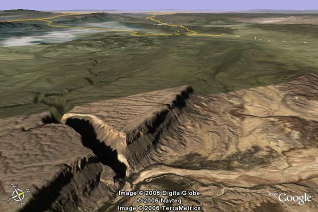
The “Google Earth” picture above shows Santa Elena Canyon (cut by the Rio Grande River) at the west end of Big Bend National Park, Texas. The Rio Grande River marks the boundary between the United States (to the right of the river/canyon) and Mexico (to the left of the canyon). Texas State Route 170 shows up as a dashed line in the upper right corner of the picture.
If the Rio Grande River were to pick a route from highway 170 (in the background) to the foreground based on present topography, it could stay to the right of the cliff area and never have to exceed 2,600 ft. above sea level. However, as seen in the picture it tracks left of the mesa and then cuts through it. Where it emerges from Santa Elena Canyon, the top of the mesa is slightly over 3,600 ft. above sea level. At the Rio Grande’s exit from the canyon, the elevation is about 2,160 ft. Thus the maximum depth of Santa Elena Canyon is about 1,450 ft.
The mesa was produced by a fairly recent (starting less than 5 million years ago) uplift to the left of the Terlingua Fault. Before movement along the fault started, the ground surface to the left of the fault (left side of the picture) was a little lower than the ground to the right. The Rio Grande River followed this lower route. As the mesa began to rise, the erosive power of the Rio Grande was able to cut down as fast as the mesa was rising. The river was acting as a stationary band saw that was cutting a groove into the rising terrain to the left of the fault. The more the mesa rose, the deeper the groove became.
Today “the groove” is nearly 1,500 feet deep. There is a tendency to think that ground surfaces are static and the river eroded downward to form the canyon. However, this conclusion is in error. It is the river that has maintained a roughly static elevation. As the mesa rose, the abrasive “sandblasting” action of the river kept cutting into “ground that got in the way”.
Wind River
Canyon, Wyoming
The picture above looks northwest over the Owl Creek Mountains and Wind River Canyon, Wyoming. The large lake is Boysen Reservoir (about 4,740 feet above sea level) which is held back by Boysen Dam at the south (left) end of Wind River Canyon. Thermopolis, Wyoming is in the Big Horn Basin and can be seen near the right edge of the picture. Its elevation is about 4,330 feet above sea level. In between, the Wind River cuts through the Owl Creek Mountains. Boysen Peak (far side of the canyon) tops out at over 7,500 feet. The mountains on the near side are over 8,000 feet above sea level. The official explanation for Wind River Canyon is the following sequence:
1) The Owl Creek Mountains were uplifted in Laramide time (~50 to 70 million years ago).
2) Subsequently they were buried by sediments “washed in from elsewhere” to form a level surface.
3) The Wind River developed northward (left to right) over the top of this buried mountain range.
4) Renewed regional uplift has led to recent erosion.
5) The softer sediments to the north and south of the range were eroded away, and except for erosion caused by the river, the mountain range has been exhumed.
This process, if true, would be a classic example of superimposition.
While the above sequence has been accepted for years, it appears this is not what really happened. It appears that Wind River Canyon may be an example of “Antecedence” instead of superimposition.
If in fact, Wind River Canyon is actually an example of antecedence, then the following sequence appears more likely.
1) During the Laramide, an initial shove northward of the Wind River Basin (left edge of the picture) pushed part of the basin under what is now the Owl Creek Mountains. A lower version of the range was uplifted. If the Wind River were present at this time (and it may have been), it would have been flowing northward through Mesozoic layers that have long since been eroded from the crest of the range.
2) A long period of erosion beveled the Mesozoic layers from the crest of the ancestral Owl Creek Mountains. There would also be thin layers of sediments deposited on both sides of the mountains. The result was a nearly level plane. If the Wind River had not been present in the early Tertiary, it could have easily established its current course toward the end of this long interval.
3) A second push in the last 15 million years has raised the Owl Creek Mountains to their current height. As the mountains rose, the Wind River cut Wind River Canyon.
The antecedence model appears to fit what we actually see much better than the superimposition model. Thus Wind River Canyon is presented here as an example of antecedence and not superimposition.
A more complete argument for antecedence vs. superimposition is in the “Big Horn Basin, Wyoming - Antecedence vs. Superimposition” section further down this page.
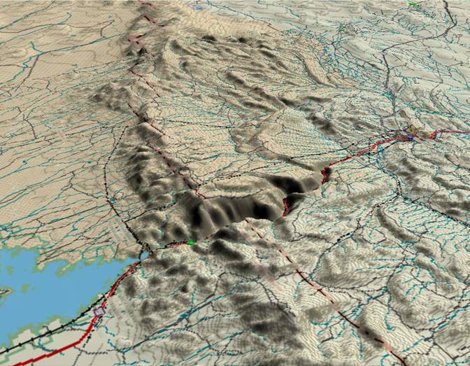
Shoshone Canyon,
Wyoming
The picture above is a view looking toward the northeast with Buffalo Bill Reservoir in the foreground and the Rattlesnake Range in back of it. Cody, Wyoming is in the distance on the far side (east) of the mountains. The Shoshone River has cut Shoshone Canyon through the range.
Buffalo Bill Dam was completed in 1910 and in due course backed up the reservoir as seen in the picture. The actual river course cuts through the Rattlesnake Range producing Rattlesnake Mountain on the left and Cedar Mountain on the right. The depth of Shoshone Canyon is nearly 3,000 feet as measured from Cedar Mountain and over 3,500 feet as measured from Rattlesnake Mountain. An obvious question is: Why did the river take a path through the mountain when a nice easy, 2,500 ft lower route was available just to the right of the mountain?
The standard answer is that Shoshone Canyon is the result of the river being superimposed over the top of the mountain. Thus the sequence of events would be:
1) The Rattlesnake Range was uplifted during the Laramide period of mountain building (50 to 70 million years ago).
2) Subsequently the Rattlesnake range was buried by sediments “washed in from elsewhere”, and the result was a level surface that buried the mountain range.
3) The Shoshone River developed eastward over the top of the buried mountain range.
4) Renewed regional uplift has led to recent erosion.
5) The softer sediments to the east and west of the range were eroded away, and except for erosion caused by the river, the mountain range has been exhumed. Rattlesnake Mountain is the remnant to the north of the canyon and Cedar Mountain is the remnant to the south.
This process, if true, would be a classic example of superimposition.
While the above sequence has been accepted for years, it may not be what really happened. It appears that Shoshone Canyon may be an example of “Antecedence” instead of superimposition.
If in fact, Shoshone Canyon is actually an example of antecedence, then the following sequence would be true.
1) During the mid Tertiary, much of the area in the vicinity of Cody, WY was beveled down to Mesozoic layers. This includes two anticlines that had been uplifted in Laramide time just south of Cody. (The remnants of both of these anticlines are included in the visible portion of the upper right corner of the picture.) The Rattlesnake Range did not exist yet.
2) The Shoshone River established its course eastward over what would become Rattlesnake Mountain.
3) Then as the Rattlesnake Range was uplifted (most likely within the last 10 million years), the river cut the canyon.
The antecedence model appears to fit the observations better than the superimposition model. Thus Shoshone Canyon is presented here as an example of antecedence and not superimposition.
A more complete argument is in the “Big Horn Basin, Wyoming - Antecedence vs. Superimposition” section below.
Big Horn Basin,
Wyoming - Antecedence vs. Superimposition
If you look at just about any geology text about Wyoming, and in particular its coverage of the Big Horn Basin, you will find a “standard explanation” on how rivers were able to cut across mountain ranges to form canyons. The standard explanation is:
1) The mountain ranges were uplifted in Laramide time (~70 to 50 million years ago)
2) Sediments that eroded off of these initial mountain ranges were incorporated in subsiding basins. (~60 to 30 million years ago - and no problem here.)
3) Continued erosion of the old mountain ranges filled in the basins - burying some of the mountain ranges. (~30 to 5 million years ago - Oligocene/Miocene time)
4) New river systems developed across the buried mountain ranges (A very fuzzy ~5 to 2 million years ago)
5) Regional uplift in the last few million years, Quaternary time, has led to erosion and exhumation of the previously buried mountain ranges. The rivers that had found routes over the buried mountain ranges maintained their new routes, and cut down into the ranges to form canyons as the sediments of the previous 30 million years were washed away.
The process of burying a mountain range, establishing a river system on top of it, followed by erosion, removal of the recent sediments and down-cutting by the river into the mountain range to form a canyon is summed up by the word “superimposition”. It is a perfectly valid sequence of events. However, the reality of the Big Horn Basin appears to be another process called “antecedence” and not superimposition. It appears the superimposition model was adopted years ago before all the facts were known, and it has been copied down from one text to another ever since.
The superimposition model assumes there was only one period of mountain building - the Laramide. This forces a sequence of contortions to get river systems to cross mountain ranges. For example, how do you get the Wind River to cross the Owl Creek Mountains to form Wind River Canyon?
A second method of forming canyons through mountain ranges is “antecedence”. In antecedence, a river system initially establishes its course by following the lowest route across a relatively level plain. Subsequently, a mountain range may be uplifted somewhere along this route. If the river has enough erosive power, it can erode down through the rising block of the mountain range as fast as the mountains rise. The result is a deep groove that is cut into the rising mountains. We of course call the “deep groove” a canyon.
The cutting process is very similar to what happens if you lift a block of wood up into a band saw. The band saw cuts a groove into the wood. We tend to think of a canyon as an example of a river cutting down through a “stationary” land surface. In many cases, it is the river that is maintaining a “stationary” elevation, and what it is doing is abrading away a rising mountain mass that keeps trying to get in its way.
The sections below look at the Wind River Canyon, Shoshone Canyon, and other features in the Big Horn Basin area to compare the superimposition model vs. the antecedence model. For years, standard geology texts have used the superimposition model. It is the author’s conclusion that the “antecedence” model is closer to what is actually observed.
1) The superimposition model requires enough sediment to be brought in “from elsewhere” during the Oligocene/Miocene to bury the Big Horn Basin (~10,000 sq. miles) under some ~3,000 feet in sediments. Also, you have bury the Wind River Basin (another ~10,000 sq. miles) to an equal depth. Throw in additional thousands of sq. miles that spill northward out of the Big Horn Basin and eastward out of the Wind River Basin. In total, this will require well in excess of 10,000 cubic miles of sediments. Where could they have come from?
The combined amount of eroded material from the Wind River Mountains, the Absaroka Mountains, and the Beartooth Mountains starting with the Laramide might at best be a couple of thousand cubic miles. (Don’t include the Big Horns and the Owl Creek Mountains as they have to be buried, and thus at best they can only be minimal net contributors.) Most of this “at best - couple of thousand cubic miles” went down with the basins in the early Tertiary. Where could the required additional 10,000+ cubic miles come from?
The sediments couldn’t have come from the south as most of the area to the south was occupied by other basins throughout the Cenozoic, and thus would have trapped any sediment that might have been in transit. The surface to the east and north of the Wyoming basins is lower, and thus these regions couldn’t have been a source. Where could this huge volume of sediment have originated?
If instead you use the antecedent model, huge volumes of sediment are not needed. However, antecedence does require recent mountain uplifts. For the Big Horn Range and the Owl Creek Mountains you need at least 2 periods of uplift. The first of course is the Laramide. A second series of uplifts appears to have taken place in the last 10 to 15 million years. The Wind River, the Shoshone River, and the Big Horn River (Big Horn Mountain portion) had established their current courses before this more recent period of uplifts. Then as the mountain ranges rose, the rivers cut their current canyons. (There has also been regional uplift across much of the Rocky Mountain region during this period.)
2) If the superimposition model is going to be correct, you have to get rid of the thousands of feet of sediments within the last few million years. Not only do you have to get rid of the sediments, you have to leave the nearly level surface that is observed in the basins today. (This includes some very flat benches in Big Horn Basin.) The Colorado River has removed thousands of feet of material in the Grand Canyon over the last 5.4 million years, but the result is a long way from a level surface. The Big Horn and Wind River basins do not have massive cliffs. They are mostly flat.
You not only have to get rid of the thousands of feet of Oligocene/Miocene deposits, you have to remove all traces that they were ever there. A few million years of erosion over tens of thousands of square miles should have missed big clumps of material. These big clumps should still show on geologic maps. They are not there. There are thin Oligocene/Miocene layers that can still be found further south (a long way from the Big Horn Basin) along the Sweetwater River (and isolated locations in the Powder River Basin), but these are local to the areas where they are found today. It is also important to note that these are thin layers - not the thousands of feet that would be required.
3) How rapidly would these Oligocene/Miocene deposits have to be eroded? If you are going to rid of > 10,000 cubic miles of material in a few million years, you would need a very rapid erosion system. There are glacial moraines in the Bull Lake Valley (NE side of the Wind River Mountains in the west end of the Wind River Basin) that date back 200,000 years to the “Bull Lake” glacial advance. There is no sign here of any very rapid valley erosion over the last 200,000 years.
There are many more pieces of evidence that make things very difficult for the superimposition model. For example, there are two Laramide age anticlines within 10 miles of Cody, WY (They bracket state Route 120 south of Cody) that have been beveled down to virtually nothing. (See picture above) Superimposition states that Rattlesnake Mountain (Shoshone Canyon) dates to this age. If Rattlesnake Mountain were this old, how was it able to remain unscathed when it would have been subject to the same conditions that have leveled these two other anticlines within a 15 mile range to the southeast? (or vice versa: How were the anticlines leveled if they had been buried along with Rattlesnake Mountain?) Antecedence has a simple answer. Rattlesnake Mountain is much younger.
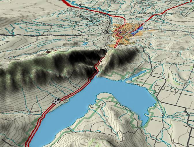
Weber and Ogden
Canyons, Utah
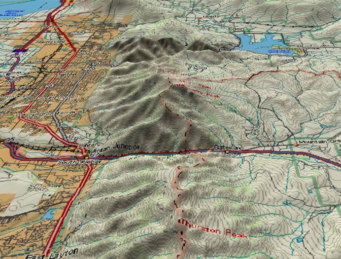
The picture above shows two canyons that cut through Utah’s Wasatch Mountains. In the foreground, the Weber River flows from east to west (right to left) through the range to produce Weber Canyon which is over 4,000 feet deep as measured from mountain tops on both sides of the canyon. The major highway is Interstate 84.
In the background, the Ogden River flows from Pineview Reservoir (right) through Ogden Canyon and exits onto the flats at Ogden, Utah (left). It is over 3,000 ft. deep as measured from Lewis Peak (just north of the canyon), and over 4,000 ft. deep as measured from Mt. Ogden which is on the south side of the canyon.
Both of these canyons are examples of “antecedence”. 30 million years ago, the Wasatch Mountain Range did not exist. However, both the Weber and Ogden Rivers were in place as they were draining westward off of mountain ranges that were uplifted earlier in Utah’s geologic history.
Starting some 20 (+/-) million years ago, the Wasatch Ranges began to rise. However, both rivers were in place, and were able to erode down as fast as the Wasatch Range rose. The rivers played the part of stationary band saws and started cutting grooves into a rising mountain range that kept “getting in the way”. Today we see the result of these grooves only we call them “canyons” instead of “grooves”.
Geology is not static condition. It is very much a “work in progress”. The Wasatch Range is still rising. Every once in a while the forces that are lifting it overcome the friction that exists on the defining faults. At this point the fault says “uncle” and the mountain range will lurch upward. (Alternately this can be described as Ogden lurching downward.) The rivers will redouble their efforts to cut down to where they were just before the lurch. And the people in Utah will turn on their radios and television sets to find out what interrupted their normal activities.
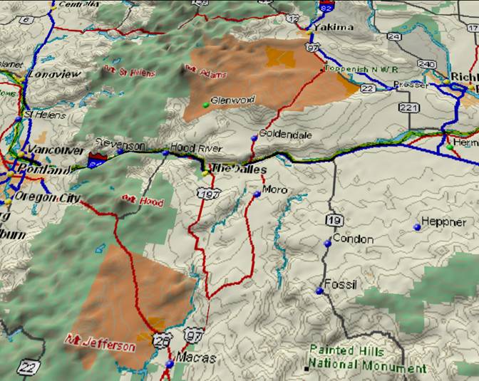
Snake River
Canyon, Oregon / Idaho Border
(Hells Canyon)
(Hells Canyon)
The picture above looks north across the Wallowa Mountains in northeastern Oregon. The Snake River enters near the center of the lower edge, bears to the right of the highest part of the range, and then continues north (toward the upper right) to cut through additional ranges. The result is “Hells Canyon”, the deepest canyon in the United States.
If the Snake River were to follow today’s topography, it would follow the broad plain of the Powder and Grande Rhonde River systems around the left (west) side of Oregon’s Wallowa Mountains. If you followed this route today, you could go from the foreground, bear left around the Wallowa Mountains, follow the Grande Rhonde River down to where it joins the Snake River north of the mountains, and continue on to the Pacific Ocean; and never exceed 3,500 feet above sea level. Instead the Snake River cuts to the right, and for 130 miles cuts through mountains and plateaus that are continuously 5,000 to over 9,000 feet above sea level. (For that matter the Grande Rhonde River has cut a canyon over 2,000 feet deep to maintain its course.)
Why and how did the Snake River take the difficult route through the mountains instead of an easier route around them?
The answer is very simple. Twenty million years ago the mountains weren’t there. The Snake River (and the Grande Rhonde) established their courses over relatively flat lowlands. As the mountains and plateaus rose, the two rivers were able to cut down fast enough to maintain their courses. The process continues today.
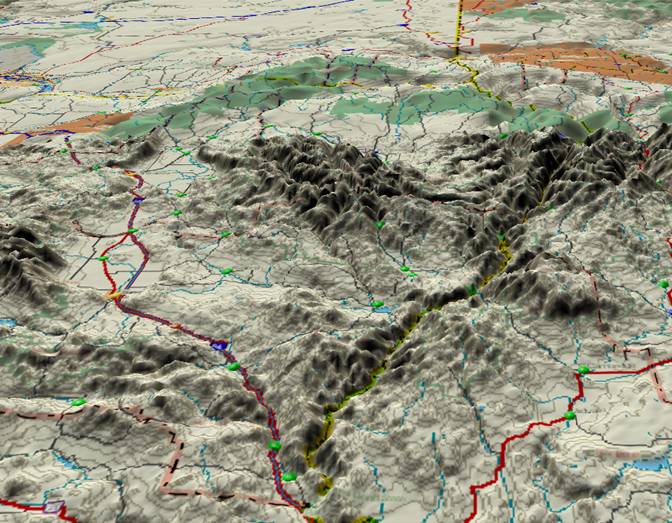
Columbia River
Gorge, Oregon and Washington
The view above looks north from Oregon into Washington. Portland, Oregon is on the extreme left edge. The Columbia River enters from the top edge (right of center), flows southeastward until it is slightly off the right edge, and then turns west (left) to cut through the Cascade Ranges to emerge near Portland. At Bonneville the Columbia River Gorge is over 3,000 feet deep as measured by mountains on both sides of the river.
The Columbia River Gorge is another example of “antecedence”. The ancestral Columbia River was in place long before the Cascade Mountains rose. The Cascades are another “young” mountain range and only began to rise about 20 million years ago. As the mountain range rose, the Columbia River had enough erosion power to maintain its course. Sand and silt in the Columbia River acted as a “sandblasting” agent. Without its erosive ability, the Columbia might have been blocked and forced to find some other easier route to the ocean. However, the Columbia was equal to the task. As the mountain range rose, the Columbia was able to abrade anything and everything in its path out of existence. Additional uplift history of the Cascade Range is available at: “The Geology of Washington, Southern Cascades” http://www.dnr.wa.gov/geology/scascade.htm
Return to main Ancestral Rivers Page
Web page generated via Sea Monkey's Composer
within a Linux Cinnamon Mint 18 operating system.
(Goodbye Microsoft)