
Durango Bill’s
Ancestral Rivers of the World
Ancestral Rivers
of the Eastern United States
by
Bill Butler
by
Bill Butler
Antecedence and superimposition are geologic processes that explain how and why rivers can cut through mountain systems instead of going around them. Examples (with pictures) are from the eastern United States.
Featured Areas
Hudson River (Taconic Mountains)
between Peekskill and Newburgh, New York.
Delaware Water Gap (Delaware River
on the New Jersey/Pennsylvania Border)
Susquehanna River north of Harrisburg, Pennsylvania
Potomac River at Harpers Ferry
New River near the Narrows, Virginia
French Broad and Pigeon Rivers, North Carolina to Tennessee
Tennessee River – Alabama/Mississippi/Tennessee section
Susquehanna River north of Harrisburg, Pennsylvania
Potomac River at Harpers Ferry
New River near the Narrows, Virginia
French Broad and Pigeon Rivers, North Carolina to Tennessee
Tennessee River – Alabama/Mississippi/Tennessee section
All pictures were generated via Delorme’s Topo USA computer program
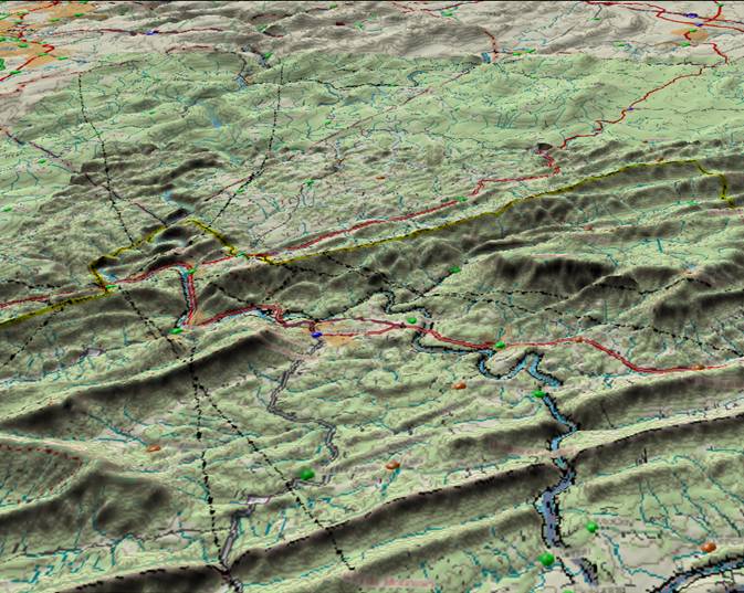
Hudson River cuts
through the Taconic Mountains between Newburgh and Peekskill,
NY
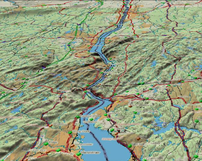
The picture above shows the Hudson River where it cuts through the Taconic Mountains in eastern New York State. The Taconic Mountains are one of the oldest recognizable mountain systems in the United States.
Some 500 million years ago, movements of the earth’s crust (plate tectonics) began squeezing the Iapetus Ocean (long vanished predecessor of today’s Atlantic Ocean) out of existence. At the time, North America was an island continent (much like today’s Australia), centered a little south of the equator, and rotated from today’s orientation such that due north from New York city would take you toward today’s extreme southwestern Canada.
Over the next 250 million years, most of the earth’s land masses would converge to form the super-continent Pangaea.
The Iapetus Ocean separated the east coast of what would become the United States and the continent of Africa. As the content of Africa closed in, there were a couple of island arcs (similar to today’s Aleutian Islands) that crumpled into North America as well as the final collision with Africa. The resultant crumpling of the earth’s crust produced today’s Appalachian Mountains. There were three distinct phases of mountain building within this process. These were the Taconic (~470 to 450 million years ago), the Acadian (~400 to 350 million years ago), and the Appalachian (~300 to 275 million years ago) orogenies.
In the Taconic event, the earth’s crust was broken into a series of horizontal sheets/layers which were then shoved on top of each other. The process was similar to a deck of cards that initially is spread out with the cards slightly overlapping. If you then push the cards together, the individual cards will slide over each other and build up into a stack.
One of these sheets/layers of rock that was stacked was a hard erosion resistant layer called the “Taconic Klippe”. The “Taconic Klippe” itself did not get pushed to high elevations, but other layers were stacked on top of the Taconic Klippe, and they formed an impressive mountain range. The Taconic Klippe extends north-northeastward to include southwestern Vermont. There were also limestone layers that were stacked and buried. It gets hotter as you go deeper into the earth, and with time these limestone layers were “cooked” to become Vermont’s famous marble.
In the last 200 million years the super-continent Pangaea rifted apart. The Atlantic Ocean has filled in this rift. The new rift that opened was slightly to the east of the old Iapetus Ocean with the result that a section of what came in as part Africa remained attached to North America when the new rift opened. The “technical name” for this adopted chunk of land is “New Hampshire”. Thus New Hampshire geology is much different than that for Vermont. (Ditto for much of the rest of eastern New England.)
The Appalachians are old mountains and with time erosion beveled off the high mountains/layers and filled in some of the valleys with sand and gravel (some of which hardened into conglomerates). The end result was a nearly flat surface. South and southeastward flowing rivers developed across this flat surface. One of these rivers (which would become the Hudson) happened to be above a portion of the old erosion resistant Taconic Klippe.
Over the last few tens of million years there has been a mild regional uplift which has allowed erosion to set in again. Rivers (and more recently, glaciers) have stripped off enough material to expose the Taconic Klippe. The Hudson River was over the Klippe, but it was able to erode down fast enough to stay in its original path.
Today, the erosion resistant Taconic Klippe has emerged as a low range of mountains. The Hudson River was “superimposed” above it millions of years ago, but has been able to erode down fast enough to maintain its original path. It thus cuts through the Taconic Mountains instead of “finding” an easier path somewhere else.
Delaware Water
Gap (Delaware River on the New Jersey/Pennsylvania Border)
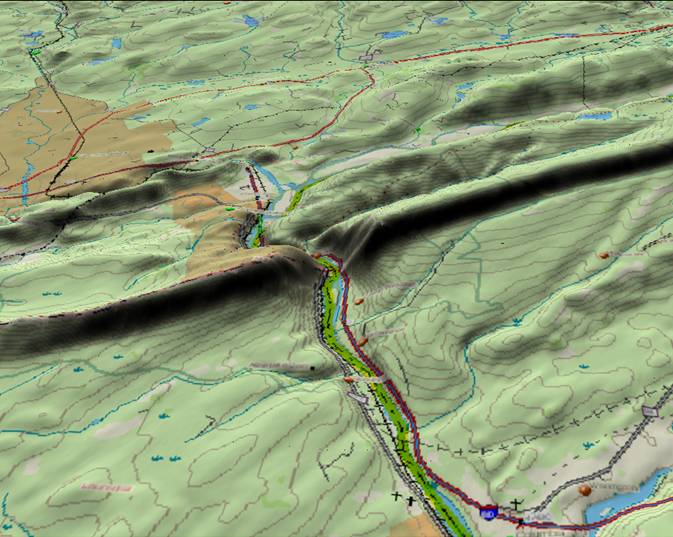
The Delaware Water Gap was an important route for early settlers that were headed west. Over geologic time the Delaware River had eroded a path though upturned layers of hard rock, and it was much easier to build an early road near the river as opposed to climbing over 1,000 feet to go over the mountain. Today Interstate Route 80 follows the same principle.
The geologic history of the area is similar to that given above for the Hudson River. Here surface layers of rock were simply folded into long ridges as opposed to the fracturing in the Taconic Mountains. Again, a long period of erosion followed the original mountain building, and a nearly flat surface resulted. The Delaware River developed southeastward across this flat surface.
Recent mild regional uplift has allowed erosion to set in again. The upturned edges of the harder rock layers in the old folds have resisted erosion and now produce long ridges. There are many streams and rivers that had developed across the old flat surface. As erosion set in again, if they had enough erosion power, they were able to maintain their paths by cutting down into the harder ridges. Thus, mountain gaps are common in this area of the Appalachians.
Susquehanna River
north of Harrisburg, Pennsylvania
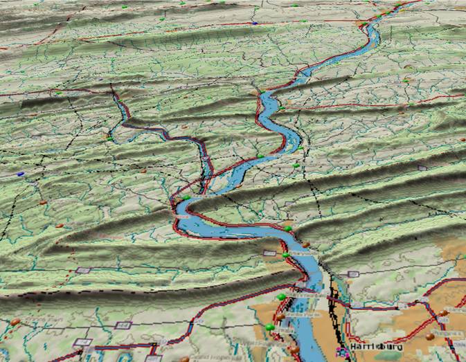
The geologic history for the Susquehanna River near Harrisburg, PA (lower right corner) is very similar to that for the Delaware Water Gap. The ridges are uniformly about 1,000 feet higher than the river. As with the other pictures, the view is toward the north and river flow direction is from north to south (top edge toward the bottom edge).
Potomac River at
Harper Ferry, Maryland / Virginia
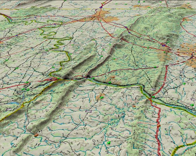
These ridges in the Appalachian Mountains that cross the path of the Potomac River have a history similar to that of the previous rivers. Here the Potomac River enters from the top left corner and flows toward the lower right corner. The Shenandoah River enters from the lower left edge and joins the Potomac at Harpers Ferry just before the Potomac cuts through the first ridge. Washington, D.C. is well off the lower right corner.
As in the previous views, the ridges rise about 1,000 feet above the river level.
New River,
Virginia
View of the New River from just north of Radford, Va to the Narrows, Va. Here the New River enters from the lower right corner and flows northwestward through the ridges and off the top edge of the picture into the 3,000+ foot-high Appalachian Plateau.
While the previous locations were examples of “superimposition” where the mountains were in place first and rivers subsequently developed on a superimposed flat surface, the New River is an example of “antecedence” as its ancestor was in place before the Appalachian Mountains were crumpled into existence. As such, the section of the New River that flows northwestward across the Appalachians has to be one of the oldest rivers in North America.
Some ~300 million years ago, river drainage in this section of the New River developed from southeast to northwest. As the Appalachian Mountains rose across the path of the ancestor to the New River, the old river had enough erosive power to maintain its path. Eventually Africa collided with North America, and the only route to the sea for this ancient river solidified as a southeast to northwest path.
Subsequently, as land in the southwestern United States rose above sea level, this ancestral drainage extended westward. Zircons (microscopic rock crystals) that originally came from the southern Appalachians were transported to the American southwest where they are found today in Mesozoic sandstone layers.
French Broad and
Pigeon Rivers, North Carolina to Tennessee
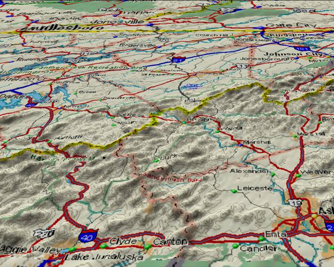
The New River isn’t the only river that flows from southeast to northwest across the highest portions of the Appalachian Mountains. The picture above shows an area stretching from Asheville, NC in the lower right corner to Douglas Lake, TN (slightly above the center of the left edge.)
Drainage for the French Broad River originates on the South Carolina border (well south of Asheville) and continues north-northwest from Asheville to cross the highest part of the Appalachians near the center of the picture. From there, the French Broad turns west to Douglas Lake, Tennessee. Below Douglas Lake, the French Broad merges with the Holsten River to form the Tennessee River.
Interstate 40 (Lower left corner) roughly follows the Pigeon River which flows from Clyde (lower left corner) across the Appalachians to where the Pigeon River joins the French Broad just before reaching Douglas Lake.
Both rivers appear to date back to Pangaea time and appear to be every bit as old as the New River.
Tennessee River –
Alabama/Mississippi/Tennessee section
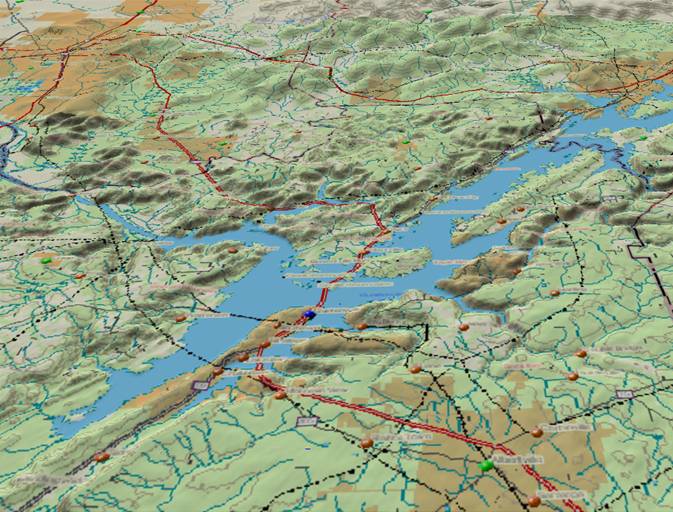
The picture above shows Guntersville Lake at the southernmost point in the Tennessee River’s path. Logically, the shortest distance for the Tennessee River to continue to the ocean would be to continue flowing south to the Gulf of Mexico. Instead, the Tennessee River turns west-northwest and then north to join the Ohio River. Why the river takes this illogical path has been subject to much controversy.
The current Tennessee River looks like it has been pieced together from at least three sections that have different origins in topography and time. Section one consists of multiple headwater tributaries (also see French Broad, above) down to Guntersville Lake and Dam. In section two, the river cuts through the ridge on the west side of the lake (see the above picture) and flows west-northwest to the Alabama/Mississippi/Tennessee border. In section three, it flows due north to finally join the Ohio River.
The origin of section three appears highly illogical if you just look at current drainage patterns. There is considerable difference of opinion regarding this portion of the river’s path, but it is the author’s conclusion that it is a remnant of a drainage system that began 250 million years ago.
250 million years ago river drainage in western Tennessee could not go east as the Appalachians and Africa blocked any path to an ocean. Similarly, drainage could not go south as there were more mountains blocking that potential route. Thus drainage was initially to the north with an eventual extension to the western U. S. Zircons in late Paleozoic and Mesozoic sandstones in the Colorado Plateau can be traced back to their origin in the southern Appalachians. (For example, see: http://gsa.confex.com/gsa/2010AM/finalprogram/abstract_178548.htm and http://gsa.confex.com/gsa/2010AM/finalprogram/abstract_176797.htm)
Geologic maps of Tennessee (see http://www.state.tn.us/environment/tdg/bigmap.shtml or http://geology.about.com/od/stategeologicmaps/ -> Tennessee) indicate bedrock in this area dates back this far, and the more recent Cretaceous rocks could easily be deposits by a sluggish ancestral river.
Another model for the Tennessee River proposes that at one time the Tennessee River continued west to the Mississippi via the current route of the Hatchie River, and shifted to its present northward course via “stream capture”. (See http://gsa.confex.com/gsa/2003SC/finalprogram/abstract_48098.htm ) However, topographic maps show no evidence of any relatively low ancestral valley pathway that would support this alternate model, and the terrain surrounding the current northward portion of the river “looks very old” on topographic maps.

(Click on map for a large version)
The topo map above shows the terrain to the west of the Tennessee River where the river turns north to eventually join the Ohio River. The Tennessee River and Pickwick Dam/Reservoir are in the upper right corner. The blue line extending southward from the Pickwick Reservoir is the Tennessee-Tombigbee Waterway – a man-made canal that allows barges to take a shortcut from the Tennessee River to the Gulf of Mexico. Streams and rivers on the left edge of the map flow northwestward into the Hatchie-Tuscumbia River system. The drainage divide between the Tennessee and Hatchie Rivers is of interest.
If there were an ancestral connection between the Tennessee River and the Hatchie River, there would have to be an ancestral east to west valley system that crossed the “relatively high” ridge that separates the two drainage systems. The topo map doesn’t show any sign of an ancestral connection.
The small community of Gravel Hill in the upper left corner may be of interest. There is little information about the gravel at Gravel Hill, but there is no sign of any recent river system that could have left a gravel deposit on this relatively high ground. It would appear that the gravel is left over cobbles and deposits of the north-flowing drainage that existed over one hundred million years ago.
Return to main Ancestral Rivers Page
Web page generated via Sea Monkey's Composer
within a Linux Cinnamon Mint 18 operating system.
(Goodbye Microsoft)