
Durango Bill’s
Ancestral Rivers of the World
Ancestral Rivers
in South America
by
Bill Butler
by
Bill Butler
Antecedence and superimposition are geologic processes that explain how and why rivers can cut through mountain systems instead of going around them. The examples here (including pictures) are from South America, but other examples can be found throughout the world.
Featured areas
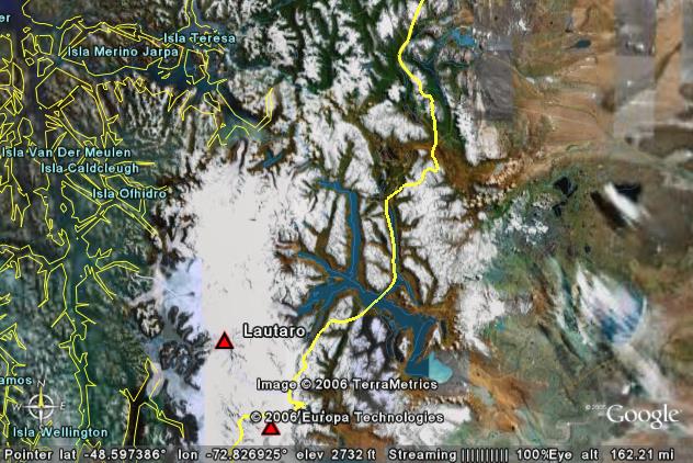
Baker River, Lago Buenos Aires
(General Carrera Lake), Argentina & Chile
Cisnes River, Chile
Grande River, Bolivia
Rio Pascua (Pascua River), Lago San Martin (Lake O’Higgins), Argentina & Chile
Patia River, Columbia
Pilcomayo River, Bolivia
Cisnes River, Chile
Grande River, Bolivia
Rio Pascua (Pascua River), Lago San Martin (Lake O’Higgins), Argentina & Chile
Patia River, Columbia
Pilcomayo River, Bolivia
Baker River, Lago
Buenos Aires (General Carrera Lake), Argentina & Chile
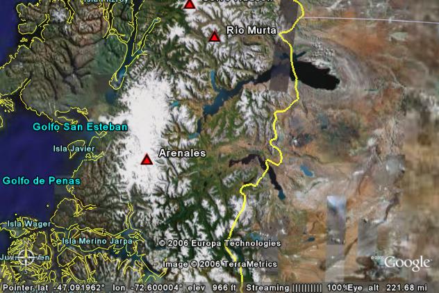
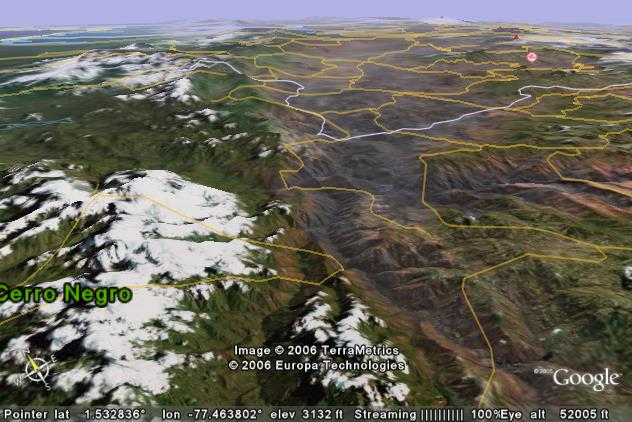
The vertical view above covers a large area along the Argentina (right) / Chile (left) border in the southern Andes Mountains. The large lake above and to the right of center is Lago Buenos Aires (General Carrera) which is about 100 miles long (including Lago Bertrand) and straddles the border. The lake’s elevation is about 660 feet above sea level.
Lago Cochrane (Lago Pueyrredon) is a second large lake that also straddles the border and is found some 50 miles to the south of Lago Buenos Aires. To the west of both lakes the high glacier covered Andes Mountains soar to over 12,000 feet.
Drainage from both lakes feeds into the Baker River which cuts southwestward across the Andes to empty into the Pacific Ocean. The lakes themselves are the result of the rising mountains which act as a dam. (Both lakes have large amounts of glacial till/moraines at their east ends which assist their current westward drainage, but these glacial debris piles are not the primary reason for the Baker River.)
The Baker River originates from the southwest end of Lago Buenos Areas and then flows south-southeast. (The river is not visible in this distant view, but if you look closely, you can see its valley just above and to the right of the “s” in the Arenales Volcano label.) Then, from about 7 miles west of the left end of Lago Cochrane, the Baker River turns southwestward, passes above the “2006” label, and enters the Pacific Ocean to the ENE of the last “a” in “Isla Merino Jarpa”. The narrow gorge where it cuts through the Andes is over 4,000 feet deep.
At times in the recent past, glaciers have blocked the Baker River. When this happened, both lakes flooded to much higher elevations and temporarily overflowed to the east.
In Pangaea time (some 200 million years ago) the Andes Mountains did not exist. The only thing west of Argentina was the Pacific Ocean. Also, Africa was joined to South America’s east coast where the Atlantic Ocean is found now. River drainage ran from east to west from Africa across Argentina to the Pacific Ocean. This was the ancestral origin of the Baker River.
When South America rifted away from Africa, the Atlantic Ocean started to open up, and most of the rivers in South America rerouted to flow eastward instead of westward. However, some of the rivers in extreme southern South America were able to maintain their ancestral westward course.
As the Andes Mountains started to rise, some of these southern rivers had enough erosion power to abrade away rising material that kept trying to get in the way. Thus today, these rivers still have narrow gorges that flow westward through the Andes.
If we project into the future, it will be a close battle between the rising Andes and the erosion power of the rivers. If the Andes rise slowly, these ancient rivers may be able to maintain their ancestral paths. If the Andes rise rapidly, they will block the rivers, and the rivers will be forced to find new exit routes that flow eastward.
One stage in this battle can be seen if you look closely at the west end of Lago Buenos Aries. There is a visible valley extending north-northwestward from the lake that passes just to the left of the label for the Rio Murta volcano. Up to two to three million years ago, this was the westward exit route from Lago Buenos Aires to the Pacific Ocean. The rising mountains overcame this ancient exit route, and Lago Buenos Airies found the next best exit. This was to the south where it joined the westward outlet from Lago Cochrane. The combined new exit is today’s Baker River.
NASA’s Earth Observatory has a good aerial view of the Baker River system at:
http://earthobservatory.nasa.gov/IOTD/view.php?id=49614
with a large photo at: http://earthobservatory.nasa.gov/images/imagerecords/49000/49614/patagonia_tmo_2011050_lrg.jpg
Cisnes River,
Chile
The boundary between Chile (left of the bright yellow line) and Argentina (right of the yellow line) is determined by the respective watersheds. The picture above shows a large area to the east of the high Andes Mountains that is part of the Cisnes River watershed that cuts through the Andes Mountains to drain into the Pacific Ocean.
The watershed for the Cisnes River can be divided into two different zones as measured from the road intersection (faint yellow lines) just to the right of the center of the picture. To the east (right) of this road intersection, the terrain is mostly open and becomes increasingly flat and dry as you move further east toward the border.
To the west, the Cisnes cuts a 4,000-foot deep gorge through the Andes to reach the Chilean fiords and the Pacific Ocean. The gorge has been widened by glacial action which allows enough room for the highway. (Faint yellow line)
The geological history is similar to that of the Baker River (above) except that no large lake is present to the east of the Andes.
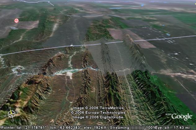
Grande River,
Bolivia
The picture above shows the headwaters of the Grande River on the eastern edge of the Andes Mountains some 90 miles south-southwest of Santa Cruz, Bolivia. Several smaller tributaries join just inside the left edge of the picture before the main river cuts through the left ridge. The river elevation in the gorge is about 1,650 feet above sea level. The crest of the ridge on both sides of the gorge is over 4,000 feet.
Once the river gets out of the first gorge, there is a second ridge to contend with on the right side of the picture. Currently, the river turns north for 11 miles before turning back to the right to cut through the second ridge. This second gorge is “only” 1,500 feet deep. The Grande River exits the picture in the upper right corner.
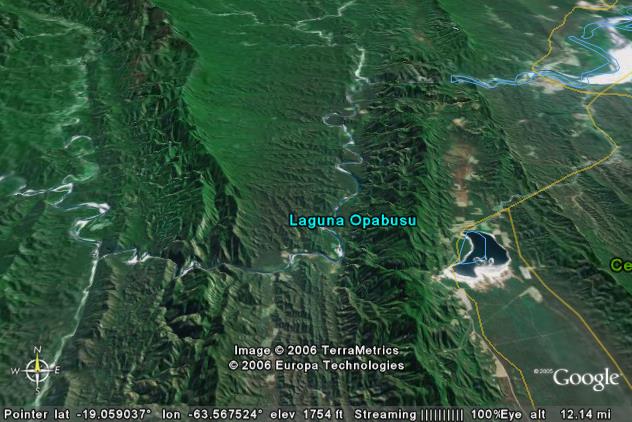
If you continue toward the east (right) from just below the “Laguna Opabusu” label, you will find Lake Opabusu (Laguna Opabusu) sandwiched between the second ridge and a lower third ridge. At one time the Grande River continued to the east through the second ridge and then turned northeastward through the third ridge. However, this area on the east side of the Andes Mountains is undergoing rapid buckling and uplift.
If we look at the left ridge in the picture, the river was able to erode down as fast as the ridge was being uplifted. Thus the river could maintain its original course. However, when we consider the battle between the river and the rising second ridge further to the right, uplift won and the river lost. The ridge rose faster than the river could erode downward. This rising ridge progressively dammed the river until it found a lower outlet route further north.
However, the remnants of this ancestral battle are still present. If you look closely at the area underneath the “usu” in “Opabusu”, you will see the remnants of an old gorge where the Grande River used to continue across this portion of the ridge. (The breakpoint may have been about one to two million years ago.)
Then there is Lake Opabusu itself. It no longer has much inlet water and the ridge to the east of it is steadily rising. There is still a low gorge to the northeast of the lake (approximately near the yellow highway), but this has been uplifted several hundred feet above the lake. Thus the lake has minimal inlet water and the outlet has been cut off. This is a hot climate with a great deal of evaporation. The minimal inlet steams bring in dissolved salts, but these are left behind as water evaporates from the lake. The white salt flats around the edge of the lake are the result.
Rio Pascua
(Pascua River), Lago San Martin (Lake O’Higgins), Argentina
& Chile
The Pascua is another river that drains the east slope of the Andes Mountains, and then cuts through the heart of the range to empty into the Pacific Ocean. The picture above shows Lago San Martin (Lake O’Higgins) which straddles the border between Argentina (right) / Chile (left). The lake is about 835 feet above sea level.
Instead of draining eastward, the lake drains north-northwestward via a 2,000-foot deep gorge through the high Andes Mountains to reach the Chilean Fiords and Pacific Ocean - just to the north of the large Southern Patagonian Ice Field. The geologic story is very similar to that for the Baker River.
A close examination indicates that drainage from Lago San Martin may be very close to reversing. In the past, glaciers have dammed the NNW exit route, and the lake overflowed to the east-southeast. As of now, it wouldn’t take much further uplift of the Andes to block this NNW exit route and permanently reverse the outlet direction for the lake.
NASA’s Earth Observatory has a good aerial view of the Pascua River system at:
http://earthobservatory.nasa.gov/IOTD/view.php?id=49614
with a large photo at: http://earthobservatory.nasa.gov/images/imagerecords/49000/49614/patagonia_tmo_2011050_lrg.jpg
Patia River,
Columbia
There are a couple of individual north-northeast to south-southwest ranges within the overall Andes Mountains. Here the Patia River starts on the east (right) side of the Cordillera Occidental Range and then turns northwest (left) to cut through the mountains. (Just to the left of the center of the picture.) Mountains on the far side of the gorge are over 7,000 feet above sea level while near side peaks are over 11,000. (The white tops are clouds - not snow). In between, the river elevation is less than 1,500 feet. The Patia River eventually empties into the Pacific Ocean off the left edge of the picture.
100 million years ago the northern Andes Mountains didn’t exist. Large areas of what is now northwestern South America were slightly below sea level. As the Atlantic Ocean continued to spread, tectonic currents rafted South America westward - directly into the Pacific Plate. South America is overriding the Pacific Plate, but the process is lifting the western edge of the continent upward. Also lighter, surface material is being caught in the middle, and as it is compressed, it crumples upward.
There have been several stages of this crumpling. Other NNE to SSW ranges are found to the east of the Cordillera Occidental. They were in place first and drainage from them toward the west was the ancestral origin of the part of the Patia River that cuts through the Cordillera Occidental range.
The Cordillera Occidental range has been uplifted after the Patia River was in place. As the range rose, the Patia was able to cut down fast enough to maintain its original path.
Pilcomayo River,
Bolivia
The picture above shows the Pilcomayo River in extreme southern Bolivia. The river rises in the Andes Mountains off the left edge of the picture and flows southeastward through the ridges in the foreground. After leaving the lower right edge of the picture, the Pilcomayo eventually joins the Parana River which reaches the ocean near Buenos Aires.
Where the river cuts through the upturned edges, the short canyons are about 2,000 feet deep.
The ridges are formed by harder layers within sedimentary rocks. The flat plains in the right portion of the picture are being pushed westward (left) by plate tectonics. Where they override the Pacific Plate, major crumpling is pushing up the Andes Mountains. Here on the eastern edge of the “crumpling”, folding and faulting are just beginning to form new mountains.
The Pilcomayo River established its course early in this process when the only “crumple” zone was off the left side of the picture. As the crumple zone propagated further east, folding and faulting began within the picture area. As the sedimentary rocks are folded/faulted upward, softer layers are eroded away while the upturned edges of the harder layers remain to form the ridges. As seen in the picture, the Pilcomayo River has been able to erode down as fast as the ridges rise, and thus it has been able to maintain its original course.
Return to main Ancestral Rivers Page
Web page generated via Sea Monkey's Composer
within a Linux Cinnamon Mint 18 operating system.
(Goodbye Microsoft)