
Durango Bill’s
Ancestral Rivers of the World
Ancestral Rivers
of Mexico, Western Canada, and Alaska
by
Bill Butler
by
Bill Butler
Antecedence and superimposition are geologic processes that explain how and why rivers can cut through mountain systems instead of going around them. Examples (with pictures) are from Mexico, western Canada, and Alaska.
Featured Areas
Bustamante Canyon (Canon
Bustamante), Mexico
Peace River / Williston Reservoir, British Columbia
Stikine River, British Columbia / Alaska
Alsek River, Yukon Territory / Alaska
Copper River, Chugach Mountains, Alaska
Nenana River, Alaska Range, Alaska
Delta River, Alaska Range, Alaska
Peace River / Williston Reservoir, British Columbia
Stikine River, British Columbia / Alaska
Alsek River, Yukon Territory / Alaska
Copper River, Chugach Mountains, Alaska
Nenana River, Alaska Range, Alaska
Delta River, Alaska Range, Alaska
Bustamante Canyon
(Canon Bustamante), Mexico
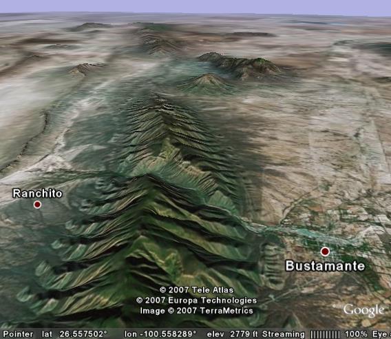
There are several rivers that cut through ridges near Monterrey, Mexico, but one of the most impressive is Bustamante Canyon which is some 62 miles north-northwest of Monterrey. In the view above (which looks north-northwestward), the Rio Sabinas cuts from left to right (from Ranchito to Bustamante) through a high uplifted ridge of sedimentary rocks. (The layers are primarily limestone and include caves.) The resulting canyon is over 3,000 feet deep.
Bustamante Canyon is an example of antecedence. The Rio Sabinas (Locally, other names are also used.) isn’t much of a river, but it (or its ancestor) was in place first, and as the ridges were folded/tilted/uplifted thousands of feet, the river was able to maintain its original course and cut down through the rising block.
As in most cases of antecedence, the river played the part of a stationary band saw. If you lift a block of wood up into the teeth of a horizontal band saw, the saw will cut a groove into the block of wood. Here, the Rio Sabinas played the part of the band saw. As the mountains rose, the river maintained its original course and cut a groove into the rising mountain block. The “groove” is now a 3,000+ foot deep canyon that cuts across the mountain range.
Peace River /
Williston Reservoir, British Columbia
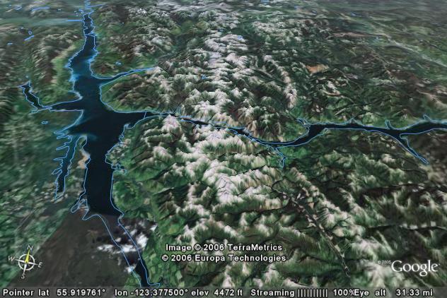
The picture above looks slightly west of due north at the headwaters of the Peace River in northeastern British Columbia. The large lake is Williston Reservoir / Lake which is backed up behind the W. A. C. Bennett Dam. The dam itself is some 15 miles off the right edge of the picture. Water flow through the river system originates as multiple tributaries that feed into the lake on the left side of the picture. The confluence produces the Peace River which flows to the right through the Rocky Mountains. Where the river cuts through the Rockies, the gorge is over 4,000 feet deep.
Williston Lake itself averages about 2,160 feet above sea level. If you follow the valley southward off the bottom left edge of the picture, you can reach the Fraser River valley and follow it down to the Pacific Ocean. If the Peace River followed this route, it would never have to climb more than 2,400 feet above sea level. (Note: While the Fraser River itself stays below 2,400 feet, recent uplifts along its route have forced it to cut through plateaus and mountain ranges, but this story is not covered here.)
Instead the river cuts through the heart of the Rockies. The ridge line of the Rockies is consistently 5,500 to 6,000 feet above sea level in the vicinity of the Peace River Gorge with some local summits over 7,000 feet. Why did the river cut to the right through the mountains instead of taking an easy route to the south?
The uplift history of this part of the Rockies is not known. What is obvious is that the Peace River had established its route before the mountains rose. If the mountains had been in place first, the river would have taken the easier route to the south. The only way the Peace River could cut through the mountains requires that the river was in place first. As the Rockies rose, the river was able to abrade down fast enough to maintain its original course.
Stikine River,
British Columbia and Alaska
Several rivers in western Canada cut through the Coast Ranges to reach the Pacific Ocean. The Fraser River (mentioned above) is one of these, but is not described further here. Two major rivers that we will cover are the Stikine River and the Alsek River.
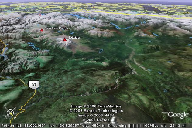
The view above looks southwestward across northwestern British Columbia and the Alaskan panhandle. The Stikine River originates some 100 miles off the lower left corner of the picture and comes into view through the compass sign at the lower left corner. From there it flows westward which in this view is toward the right and up a bit. Then the Stikine turns more to the southwest (up in the picture) and then due south (left and up) to cut through the Coast Range mountains.
The horizontal yellow line across the top of the picture delineates the border between Canada and Alaska. After the Stikine clears the mountains, it exits into the fiords and islands of the southeast Alaska panhandle near Wrangell, Alaska.
This is wild and only partially explored country. If you are into river rafting in the middle of nowhere, you might want to jot down the Stikine for future research.
The Coast Ranges of Canada and Alaska are very young. For the most part they have been uplifted in the last 20 million years. The Stikine River was in place before this uplift began. As the Coast Ranges were uplifted, the river was able to cut down fast enough to maintain an approximate stable elevation. As the mountains rose, the river cut a groove into the rising block.
On its path through the Coast Ranges, the Stikine River is within one thousand feet of sea level. The mountains on either side are over 6,000 feet above sea level. Thus the Stikine’s gorge through the ranges is about a mile deep.
If we could look at the Stikine’s path through the mountains as it existed 3 million years ago, we would see a narrow canyon comparable to today’s Grand Canyon. However, unlike the Grand Canyon, massive glaciers have periodically flowed down the Stikine’s valley over the last 2 million years. Glaciers erode sideways as well as down since the rocks and debris they carry scrape away the sides of preexisting canyons. The glaciers have transformed the previous narrow canyon of the Stikine into a classical glacial valley. The result is a typical “U” shape cross section where the valley is relatively flat but the terrain rises steeply on both sides.
Geology is a “work in progress”. While the glaciers broadened out the valley, the Stikine has already started to carve a new canyon within this broad glacial valley. If you look closely just above the “Image 2006 TerraMetrics” label, you can see the result of this recent canyon cutting.
Alsek River,
Yukon Territory to Alaska
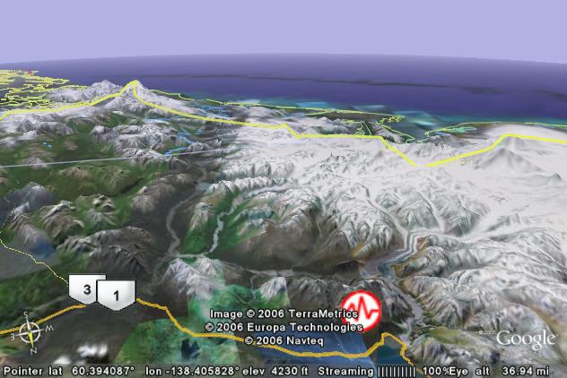
The picture above is a view to the southwest, and shows the Alsek River which starts near Haines Junction, Yukon Territory (junction of routes 1 & 3) and then flows southwestward (up) through the Alaskan panhandle to the Pacific Ocean. The tall peak near the left edge is 15,300-foot Mt. Fairweather while the even higher Logan / St. Elias massif is near the right edge. Several large glaciers can be seen winding their way downward from the St. Elias ice-fields, but if you look closely you can see gray piles of recessional moraines indicating the glaciers are shrinking due to global warming.
In the distance the Tweedsmuir Glacier (see below) flows from right to left - just upstream (toward the foreground) from where the river crosses the U. S./Canadian border.
This is an active area of mountain building. The earthquake icon marks the epicenter of a magnitude 5.1 quake that occurred in 1995. If you have Google Earth, you can zoom in to see the locations of many more recent earthquakes.
At Haines Junction, the Alsek River is about 1,900 feet above sea level. If the Alsek didn’t cut through the Coast Ranges, it could follow today’s topography eastward (toward the lower left corner and eventually join the drainage system for the Yukon River. If it followed this route, its maximum altitude would be about 2,800 feet.
Instead the Alsek River flows southwestward through these growing mountains. Today the mountains clear 7,000 feet within a few miles of the river. In the future they will be even higher.
Fish populations in the upper Alsek River are a mixture of what is normally found in both Pacific drainage rivers and the Yukon River system. Today, the Alsek River drains to the Pacific Ocean, and if this drainage had been continuous in the past, then the fish population would be similar to other Pacific drainage rivers. The Yukon drainage fish component shows that in the past, glaciers have blocked the lower Alsek River; and the river was forced to find an alternate escape route - which connected to the Yukon River. The current threat of the Tweedsmuir Glacier to block the river (see below) is a minor example of a much larger blockage at some point in the past.
The Alsek is another example of antecedence. The river was in place first. As the mountain ranges rise, the river has enough abrasive power to “sandblast” and remove material that keeps trying to “get in the way”.
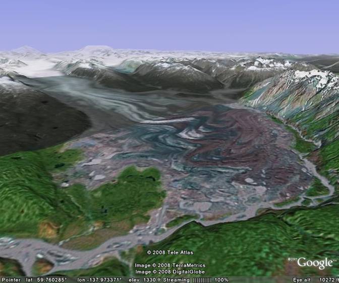
The view above looks northwestward over the lower Alsek River with the Tweedsmuir Glacier starting in the upper left corner and flowing toward the foreground. The Alsek River enters from the upper right and flows toward the lower left. Irregular surges by the glacier have squeezed and currently threaten to block the Alsek River. If the glacier does block the river, a large backup lake will form (going toward the upper right corner) behind the glacial dam. If a glacial backup lake forms, the possibility exists that the eventual overflow may breakup the lower end of the glacier - with a large portion of the lake water draining all at once in a flood.
Nov. 2007 Update
In the late summer/fall of 2007 the Tweedsmuir Glacier (At ~59.8 N 138.0 W and which is the major obstruction to the Alsek’s course) had begun another of its periodic surges. The Tweedsmuir may block the Alsek River sometime in the next few months and form a lake upstream above the blockage point. If a back-up lake forms, the river will eventually break through again, with a glacial flood ( a jökulhlaup ) downstream. Further information about the Tweedsmuir can be found at http://www.gi.alaska.edu/ScienceForum/ASF18/1878.html plus background information on Alsek/St. Elias glaciers at: http://pubs.usgs.gov/prof/p1386j/stelias/stelias-lores.pdf
Chris Larsen (Geophysical Institute, University of Alaska Fairbanks) has been photographing the Tweedsmuir Glacier, and as of Nov. 5 the Tweedsmuir’s surge has at least temporarily stopped before blocking the Alsek. (Good photos of the Tweedsmuir and other glaciers at http://www.gps.alaska.edu/chris/ )
March 31, 2008 Update
The Tweedsmuir Glacier appears to be surging again in early 2008, and once again threatens to block the Alsek River. If you are planning to raft the Alsek in 2008, check the above web links for updated information.
Sept. 2, 2008 Update
The Tweedsmuir Glacier has continued to surge and has nearly blocked the Alsek River. The National Park Service has a photo and update information at: http://www.nps.gov/glba/parknews/tweedsmuir.htm
June 2009 Update
It appears that the Tweedsmuir Glacier has stopped surging before it blocked the Alsek River. The icefront is up against the river, but it now looks like it will not block it.
Copper River,
Chugach Mountains, Alaska
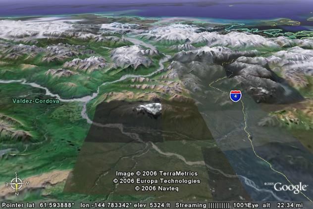
The picture above is a view looking south over the Copper River in Alaska. The Copper River enters from the lower right corner and then flows southeastward to where a major tributary, the Chitina River, joins it. Then the Copper River turns toward the south-southwest (up in the picture) and cuts through the Chugach Mountains before reaching the Gulf of Alaska.
The elevation where the Chitina joins the Copper River is around 600 feet, and its all downhill from there to the Pacific Ocean. The surrounding Chugach Mountains average 6,000 to 7,000 feet in elevation.
The many earthquakes in the area are evidence that the Chugach Mountains are continuing to be uplifted. However, the Copper River was here first. The Copper River carries a lot of silt, and this acts as a sandblasting agent to abrade a groove through the rising mountain range. Thus, the Copper River will be able to maintain its path even as the Chugach Ranges continue to rise higher in the future.
There is an interesting story regarding the origin of the name “Copper River”. The word “copper” is of course named for the chemical element copper. In August 1900 two prospectors, Jack Smith and Clarence Warner, found a “large green spot” on the south side of the Wrangell Mountains. (Upstream on the Chitina River and off the left edge of the picture.) The “large green spot” turned out to be one of the richest outcrops of copper ore that has ever been discovered. Mining operations were eventually financed by the Guggenheim family and J.P. Morgan. The name of the corporation was a slight misspelling of a glacier that terminates in the valley just below the mine. The glacier is the “Kennicott Glacier” which was named after explorer Robert Kennicott. The original mines along the headwaters of the Copper River have long since shut down, but the Kennecott Utah Copper Corporation still runs the world’s largest open pit mining operation. (The original Kennecott Copper is now a subsidiary of Rio Tinto.)
Nenana River,
Alaska Range, Alaska
There are two river systems that cut from south to north through Alaska’s Alaska Range and thus indicate a south to north drainage system existed before the mountain range rose. We will first take a look at the Nenana River.
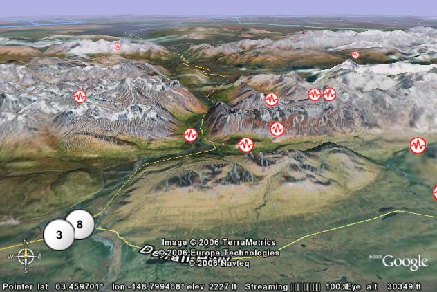
The view above looks north where the Nenana River cuts through the Alaska Range. The Nenana River enters the field of view from just below the center of the right edge. It then flows westward behind the “Reindeer Hills” (Remember this is Alaska).
The Jack River is a major tributary to the Nenana. It enters from the lower edge (left of center) and flows around the west (left) end of the Reindeer Hills. The two rivers join before they continue northward through the Alaska Range.
As indicated by the many earthquake icons, the Alaska Range is actively being uplifted today. Uplift of the range is mostly in back of a fault that extends left to right across the center of the picture. The Nenana Canyon is already 3,000 feet deep, but it is destined to become deeper with time.
The small town of McKinley Village is in the valley behind the first range of mountains. It is the jumping-off spot for tours of Denali National Park. If you are taking a trip to the area, be sure to allow enough time to take one of the guided tours. Also, if the weather is good, take a “flight-seeing trip” that originates from the McKinley Park “Airport”.
(Landing instructions from the FAA at http://www.alaska.faa.gov/fai/images/TANVLY/INR-c.jpg )
“Activate landing alert siren system for people and moose on runway”
Bring your camera, camcorder, etc. for “whatever”.
Delta River,
Alaska Range, Alaska
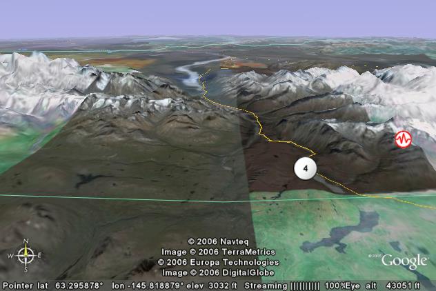
Alaska’s Delta River does a copycat story of the Nenana River (see above), but it is located some 90 miles further east. The Delta River enters from the lower edge (near the compass icon), and heads north to cut through the Alaska Range. This end of the Alaska Range is also undergoing uplift with multiple earthquakes in the area although only one shows on this more distant view.
The Delta River on the near side of the range is about 2,800 feet above sea level and drops to about 1,800 feet on the far side. Mountains immediately adjacent to the canyon are over 7,000 feet high while the high peaks near the edges are in the 8,000 to 12,000 foot range.
This portion of the Alaska Range is the site of the famous Black Rapids Glacier. While the Black Rapids Glacier is hidden in this view, it originates near the left edge of the picture and flows to the right in a valley that is between the highest visible peaks and the lower range just in front of it.
The Black Rapids Glacier “galloped” to fame in 1937 when the following excerpt appeared in Time Magazine.
"Out of Central Alaska last week
came an exciting story. The Black Rapids Glacier, long dying in
its valley 125 miles south of Fairbanks, had come to life. Its
mile-and-a-quarter face was shoving toward the Delta River and
the Richardson Highway (sole motor road from Fairbanks to the
coast), rearing ice crests to 500 feet, breaking off great land
icebergs which tumbled thunderously ahead onto the mossy valley
floor. Geologist Ernest N. Patty at Fairbanks declared this week
that if the Black Rapids Glacier is moving as reported, it is
traveling 220 feet per day, a world record."
Please see http://www.gi.alaska.edu/ScienceForum/ASF13/1342.html for more information.
Glacial surges are a result of water build-up within the glacier. If ice movement within a glacier obstructs normal drainage water, then a pool of water will accumulate. The water will tend to float the glacier as well as act as a lubricant between the glacier’s ice mass and the underlying rock. Both actions reduce friction between the glacier and the underlying rock. The reduced friction can result in a temporary rapid flow of ice down the valley.
The 1937 surge in the Black Rapids Glacier stopped before it blocked the highway. If you use Google Earth, you can see that most of the 3-mile surge has completely melted away. However the glacial advance did obliterate all the vegetation in its path. If you view the area today, there is a visible “trimline” that marks the greatest extent of the glacial surge. Areas that were not buried by the ice still have their original vegetation and are a relatively dark color. Areas that were run over by the advancing ice, are still mostly a lighter color.
Actually, if you look closely at the north side of Black Rapids Creek, you can see traces of older trimlines and terminal moraines. The hillside on the east side of the Delta River has at least one trimline indicating that at least one of these surges dammed the Delta River and produced a lake several hundred feet deep. It would have produced a “jokulhlaup” when the ice dam broke. There’s a research project waiting here for somebody’s thesis.
Return to main Ancestral Rivers Page
Web page generated via Sea Monkey's Composer
within a Linux Cinnamon Mint 18 operating system.
(Goodbye Microsoft)