
Durango Bill’s
Ancestral Rivers of the World
Ancestral Rivers
in Australia and New Zealand
by
Bill Butler
by
Bill Butler
Antecedence and superimposition are geologic processes that explain how and why rivers can cut through mountain systems instead of going around them. The examples here (including pictures) are from Australia and New Zealand, but other examples can be found throughout the world.
Featured areas
Alice Springs - Todd River
Arroyos - the Great Outback (3 pictures)
Coongan River
Fitzroy River ( 2 pictures)
Ord River
Victoria River
Kawarau River/Gorge, South Island, New Zealand
Arroyos - the Great Outback (3 pictures)
Coongan River
Fitzroy River ( 2 pictures)
Ord River
Victoria River
Kawarau River/Gorge, South Island, New Zealand
Alice Springs -
Todd River
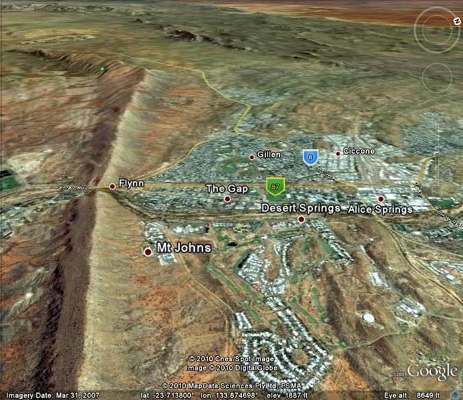
The above Google Earth view looks west northwest across central Australia’s Alice Springs. The long ridge is part of the MacDonnell Ranges. (See below for geological history) The item of interest is the Todd “River” which cuts through an upturned sandstone ridge to form the 600-foot deep Heavitree Gap. There are several other “gaps” within a 10 mile radius of Alice Springs where other streams/rivers cut through similar upturned ridges.
Rivers in central Australia are unusual as most of the time they don’t have any flowing water. When a significant rain does occur, the Todd does flow; and more importantly, it transports a load of silt and sand. The silt and sand are abrasive elements that allow the Todd to keep cutting down through the hard sandstone ridge. The process has been going on for hundreds of millions of years, and it started when local topography and rainfall amounts were much different from what we see today.
Arroyos - the
Great Outback (3 pictures), Northern Territory
Australia does have rivers with real water, but Australia would not be the same if it did not have the “Great Outback”. You could spend days trying to drive across the “Outback”, and it might seem as though there was nothing there except “miles and miles” of nothing but “miles and miles”.
Aerial views reveal a different and fascinating world. The pictures below are an excerpt from a geologic story that started long ago when the “Outback” was different.
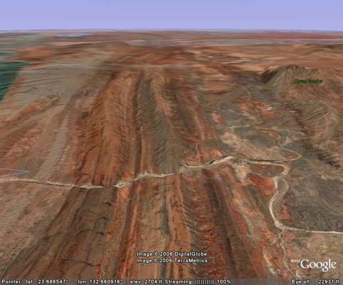
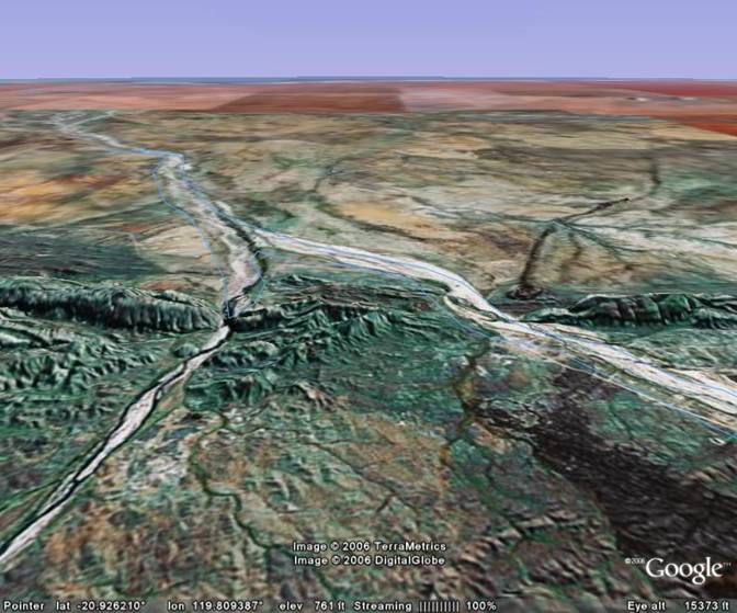
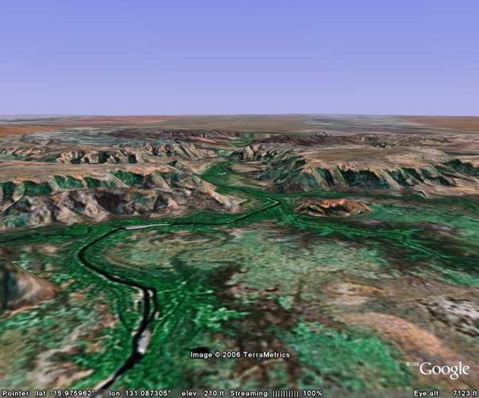
The picture above looks west-northwest over the western end of the MacDonnell Ranges some 75 miles west of Alice Springs. There is a small motel at Glen Helen just below the center of the picture where the dry stream bed enters the main ridge.
The dry steam bed actually has a name, the Finke River, and on rare occasions it does flow (from right to left). Close examination of the Google Earth photographs show there was no flowing water at the time the picture was taken, and there were just a few stagnant mud puddles.
Many hundreds of millions of years ago, there were horizontal layers of sand and silt laid down in what is the current field of view. Gradually they hardened into layers of sandstone and siltstone. The MacDonnell Ranges were subsequently uplifted some 300 to 400 million years ago. (The highest portions were off the right side of the picture.) What had been horizontal sedimentary layers were bent upward over the core of the uplifted mountain range. Mt. Sonder (right edge of the picture) is a minor remnant of this former mountain range. River drainage that developed off the south side of these mountains eroded valleys, and the remnants of these rivers persist to today. One of these ancient drainage valleys is the ancestor of today’s “Finke River”.
As the upper layers of the range erode away, the upturned layers along the flanks are gradually exposed. The harder sandstone layers resist erosion and are exposed as long ridges.
Even though the Finke “River” only flows occasionally, it still has enough erosion power to abrade down through these harder ridges. Thus today, it occupies a series of gorges that cut through the upturned sandstone layers. The gorge just below the center of the picture is over 500 feet deep.
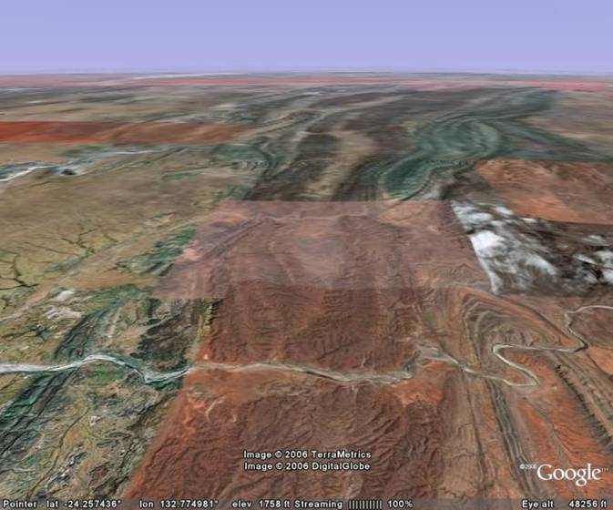
The picture above is some 40 miles south-southeast of the first picture, and looks westward where the Finke River cuts across more upturned ridges. (In this view it again flows from right to left.) The landscape was crumpled many millions of years ago, and the structural deformations probably date back to the uplift of the MacDonnell Ranges. A couple of these beveled crumples can be classified.
The structure in the lower right hand corner is the beveled remnant of an anticline. In an anticline, the center is lifted upward, and the overlying sedimentary layers are tilted so that they tilt upwards toward the center of the anticline.
The next “crumple”, that runs vertically through the center of the picture is a syncline. Here the layers are bent down toward the center of the structure. In-between the anticline and the syncline, the layers dip down sharply as you go from right to left.
Finally there is another beveled anticline in the lower left corner. (The portion of the picture in this area has a different tint and lower resolution.) Once again, the layers were bent over the top of this anticline similar to the anticline in the lower right corner.
The structural folds can be traced for many miles into the distance. The Finke River cuts across these folds since it was in place first, and has had enough erosion power to keep its ancestral path.
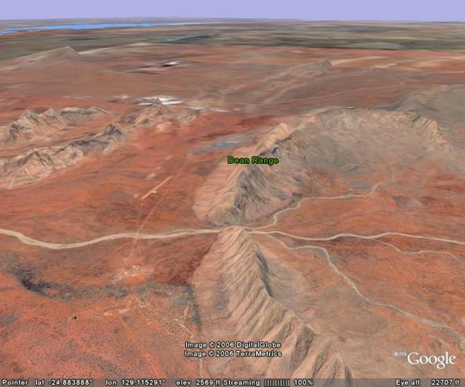
The view above looks east-northeast in another area some 125 miles west-northwest of Ayers Rock (Uluru). Another dry arroyo is cutting through a mountain range. The mountain range is identified by Google Earth as the Dean Range (part of the Petermann Ranges), and some searching through atlases found the name for the small town in the lower left quadrant as “Docker River”. (A dirt airstrip is somewhat more visible on the far side of the “river” almost directly above the town.)
The Dean Range is an upturned sandstone ridge that was bent upward over the top of a larger dome structure centered some 10 to 20 miles further to the south-southeast (off the right edge). There is very little left of the dome except slightly higher ground that serves as a source drainage area for the “Docker River”, and exposed rock layers that look much older than the sandstone in the Dean Ranges.
As for the “Docker River”, a close examination of the Google Earth (satellite) photos couldn’t even find a mud puddle. However, given the very occasional times the river does flow combined with millions of years of geologic time, the Docker River has cut a gap through the Dean Range that is over 1,000 feet deep.
Coongan River,
Western Australia
The majority of Australia’s “Ancestral Rivers” are found in Western Australia. The picture above looks north, and shows the Coongan River (left) and a tributary cutting through what appears to be another upturned sandstone ridge north of the Chichester Range.
The thin dark line that snakes upward in the right side of the picture appears to be a volcanic dike. At some point after the sedimentary layers were laid down, and before erosion exposed the current surface, there was some kind of force that pulled the upper layers of the crust slightly apart. Molten lava seeped upward into the resulting crack, and formed a thin wall of basaltic rock when it cooled. When it is exposed, it is more resistant to erosion, and thus produces a small ridge. The dark rock in the lower right corner looks as though it is part of the same intrusion.
When a mountain range is uplifted, river systems develop radially outward. They thus ignore layers of sedimentary rock that were bent up over the rising range. With time, erosion removes the upper layers, and the lower layers are revealed. Frequently, river systems are able to maintain their paths, and cut gaps through the more resistant elements within these sedimentary layers.
If you stood where the rivers are cutting through the ridge, you would see a cross section of these resistant layers. In this particular view, they would be tilted up toward the viewpoint for the picture, and tilted downward toward the distant horizon.
Fitzroy River (2
pictures), Western Australia
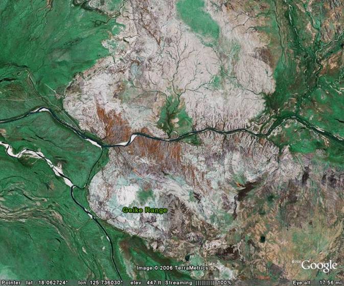
The picture above is a vertical view of a limestone dome (the Gieke Range) where the Fitzroy River has eroded down through the dome to form Geike Gorge (Geikie Gorge). The Fitzroy enters the field of view from the right edge and flows left through the dome. The small town of Fitzroy Crossing is downstream off the left edge.
The thin dark line for the river is bigger than you might think. The area is a local tourist attraction where tour boats take tourists through the gorge.
The lighter rocks in the picture are Devonian age limestones - part of an ancient 350 million to 400 million year old reef system. The uplift history of the reefs (which are on the southern edge of the King Leopold Ranges) is not known, nor is the history of the Fitzroy River known. However, the river has cut a gorge over 100 feet deep in the old limestone reefs.
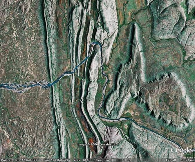
About 35 linear miles upstream, the Fitzroy has cut down through other limestone layers. The limestone layers in Geike Gorge (first picture) are essentially horizontal as they are found on the top of a dome. The layers in this picture have been tilted as they are on the southwest side of a syncline. (The axis of the syncline runs from the top to the bottom of the picture to the right of the center.)
The tilting has exposed a sequence of layers, and where these more erosion resistant layers are exposed, they produce long ridges. The Fitzroy enters from the right edge and has eroded down through these ridges before it exits the field of view on the left edge. There are other gorge systems and caves in these limestone reefs that may be of interest if you ever take a trip to the area.
Ord River, Lake
Argyle, Western Australia
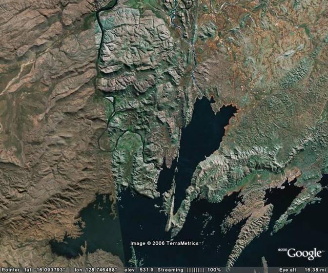
The picture above shows the extreme north end of Lake Argyle and its outlet, the Ord River. Lake Argyle is a large man-made reservoir that backs up from the Ord Dam.
The Ord River cuts through the Carr Boyd Ranges (left and above the lake) at about 150 feet above sea level. The tops of the Carr Boyd Mountains are 900 to 1,200 feet above seal level. There is an alternate path that the Ord River could have originally taken to the right of the fault (suture) zone (extends through the center of the picture) where the river would never have to travel across terrain that exceeded 340 feet above sea level. The overflow spillway for the lake was built through this lower alternate route. If you look closely at the extreme north end of the lake, you can trace the route of this overflow spillway.
Why did the river take a path through the higher mountains?
There are 2 possible reasons for the illogical course of the Ord River. In both cases the mountain route would have been lower at the time the river established its course.
Case 1) The area to the right of the fault looks like the soil/rock is less resistant to erosion than the rock to the left of the fault. Thus it erodes more rapidly. If we ran the clock backward and replaced everything that was eroded, it’s quite possible that not too far in the distant past, that this area was higher than the current Carr Boyd Mountains. This seems possible, but there are multiple other potential escape routes for the Ord River that stay under the 900-foot level, and these would also have to be blocked in the past.
Case 2) A more logical explanation is that the old fault was reactivated at some time in the last 10 to 20 million years. In this scenario the current height of the Carr Boyd Mountains is due to relatively recent uplift. Thus the Ord River was in place first at a low elevation to the left of the fault. As the mountains were uplifted, the Ord River eroded away material that kept getting in the way. Thus it could keep its original path.
There is a piece of evidence for case two. The Ord Canyon below the dam has steep sides. This is characteristic of something that has been cut in the last 10 million years.
Victoria River,
Northern Territory, Australia
The picture above looks to the north where the Victoria River follows a relatively narrow passageway into and through a low plateau in the northern part of the Northern Territory. The passageway is nowhere nears as spectacular as other canyons that we have looked at, and the view has used a vertical exaggeration factor of 3 to emphasize the relief. The river elevation as it enters the passageway is slightly under 200 feet above sea level while the top of the very flat plateau is constant between 750 and 800 feet.
What is of interest is why did the river take this path instead of going somewhere else?
The terrain to the south (in back of the field of view) is exceedingly flat. You can travel 100 miles to the south from the observation point and never exceed 600 feet above sea level. (Remember the plateau is 750 to 800 feet.) It seems highly unlikely that this huge area to the south could have eroded down to under 600 feet while the plateau was essentially untouched by erosion except in the immediate vicinity of the river.
There is an alternate escape route for the river. You could go 30 to 40 miles to the east of the observation point and then follow virtually level ground north into another drainage system and stay under 600 feet. The river didn’t take that route either. Instead it went north over a plateau that is currently more than 750 feet above sea level until you erode down to the river’s current elevation.
It appears that the river established its path when the plateau was somewhat lower than it is today. The plateau has been subsequently uplifted a few hundred feet, but the river was able to erode down as fast as the plateau rose.
The river never was at the 750-foot elevation of the current top of the plateau. It was always at its current elevation of just a couple of hundred feet above sea level. As the plateau rose, the river simply cut a groove into the rising block of material.
Kawarau
River/Gorge, South Island, New Zealand
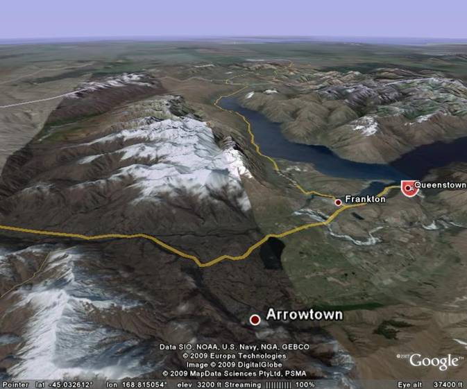
The picture above looks SSW near Queenstown, South Island, New Zealand. Lake Wakatipu is in the upper right quadrant, with the lake winding back into the mountains for a considerable distance off the right edge of the picture. The lake is some 50 miles long and very deep with parts of it as much as 300 feet below sea level. The yellow line in the lower left portion of the picture is the Gibbston Highway which follows the Kawarau River down through Kawarau Gorge.
The surface elevation of the lake is about 985 feet above sea level. If you follow the valley toward the south from the far end of the lake (go up in the picture), the maximum elevation for what would appear to be a normal exit route for the lake’s outlet never exceeds about 1200 feet above sea level. Instead, the lake’s outlet is the Kawarau River which drains the lake starting near Frankton, and then continues left through the Remarkable Mountains to exit off the left side of the picture. The Remarkables are over 5,500 feet high in the extreme lower left corner and over 7,000 feet high near the center of the picture.
Why would the river pick a route that flows through a mountain range that is a mile higher than the lake level when present topography allows an alternate route that has a maximum elevation that is less than 250 feet higher than the lake level?
The answer again appears to be an example of antecedence. If we go back some 20 (+/-) million years, the Remarkables didn’t exist. The ancestor of today’s Kawarau River flowed lazily from right to left in approximately the same path as the river’s current course. There are even some embedded meanders in Kawarau Gorge that imply a former lazy path across a relatively flat plain.
Over the last 20 million years one block of the earth’s crust has been forced upward to create the Remarkables mountain range. Another block of the earth’s crust (underlying the current lake) has sunk to form a graben. (The graben probably also includes the failed exit route to the south - up in the picture.)
The river was able to maintain its path as it eroded away the rising material that kept trying to block its path. The canyon that the river carved through this rising block of rock is today’s Kawarau Gorge. Meanwhile the bedrock beneath the current lake dropped far below sea level. It appears that recent glaciation has scoured out some of the sediments that may have accumulated in the graben which allows the bottom of the lake to still be well below sea level. As the glacial ice melted away in the last 20,000 years, the “hole” filled with water to form today’s lake.
Return to main Ancestral Rivers Page
Web page generated via Sea Monkey's Composer
within a Linux Cinnamon Mint 18 operating system.
(Goodbye Microsoft)